Juchipila | |
|---|---|
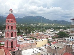
 View of the municipal seat of Juchipila. Behind the bell tower of the Church of Saint Francis of Assisi is the town plaza. | |
| Coordinates: 21°24′37″N 103°07′03″W / 21.41028°N 103.11750°W[1] | |
| Country | |
| State | |
| Established | 17 January 1825 |
| Seat | Juchipila |
| Government | |
| • Municipal president | Jose Maria Castro Felix |
| Area | |
• Total | 338.6 km2 (130.7 sq mi) |
| Elevation [1] (of seat) | 1,249 m (4,098 ft) |
| Population (2020 Census)[2] | |
• Total | 12,251 |
| • Density | 36/km2 (94/sq mi) |
| • Seat | 5,836 |
| Time zone | UTC-6 (Central) |
| • Summer (DST) | UTC-5 (Central) |
| Postal codes | 99960–99979[3] |
| Area code | 467 |
| Website | Official website |
Juchipila (Nahuatl: Xochipillan, "place of noble or beautiful flowers"[4]) is a municipality in the Mexican state of Zacatecas, located approximately 160 kilometres (99 mi) southwest of the state capital Zacatecas City.
- ^ a b "Sistema Nacional de Información Municipal" (in Spanish). SEGOB. 2010. Retrieved 11 October 2021.
- ^ a b Cite error: The named reference
panoramawas invoked but never defined (see the help page). - ^ "Consulta de Códigos Postales". Catálogo Nacional de Códigos Postales. Mexican Postal Service. 10 October 2021. Retrieved 11 October 2021.
- ^ "Juchipila". Enciclopedia de los Municipios y Delegaciones de México (in Spanish). INAFED. Archived from the original on 10 March 2021. Retrieved 11 October 2021.

