| Julian Alps | |
|---|---|
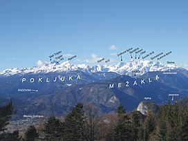
 The Eastern Julian Alps and Mount Triglav | |
| Highest point | |
| Peak | Triglav |
| Elevation | 2,864 m (9,396 ft) |
| Coordinates | 46°23′N 13°50′E / 46.383°N 13.833°E |
| Geography | |
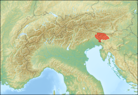
 Julian Alps (in red) within the Alps. The borders of the range according to Alpine Club classification of the Eastern Alps | |
| Countries | |
| Range coordinates | 46°20′N 13°45′E / 46.333°N 13.750°E |
| Parent range | Southern Limestone Alps |
The Julian Alps (Slovene: Julijske Alpe, Italian: Alpi Giulie, Venetian: Alpe Jułie, Friulian: Alps Juliis, German: Julische Alpen) are a mountain range of the Southern Limestone Alps that stretch from northeastern Italy to Slovenia, where they rise to 2,864 m at Mount Triglav, the highest peak in Slovenia. A large part of the Julian Alps is included in Triglav National Park. The second highest peak of the range, the 2,755 m high Jôf di Montasio, lies in Italy.[1]
The Julian Alps cover an estimated 4,400 km2 (of which 1,542 km2 lies in Italy). They are located between the Sava Valley and Canale Valley. They are divided into the Eastern and Western Julian Alps.