Junglinster
Jonglënster (Luxembourgish) | |
|---|---|
 | |
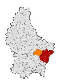
 Map of Luxembourg with Junglinster highlighted in orange, and the canton in dark red | |
| Coordinates: 49°42′40″N 6°15′05″E / 49.7111°N 6.2514°E | |
| Country | |
| Canton | Grevenmacher |
| Government | |
| • Mayor | Bernard Ries |
| Area | |
• Total | 55.38 km2 (21.38 sq mi) |
| • Rank | 6th of 100 |
| Highest elevation | 411 m (1,348 ft) |
| • Rank | 41st of 100 |
| Lowest elevation | 243 m (797 ft) |
| • Rank | 53rd of 100 |
| Population (2023) | |
• Total | 8,622 |
| • Rank | 18th of 100 |
| • Density | 160/km2 (400/sq mi) |
| • Rank | 53rd of 100 |
| Time zone | UTC+1 (CET) |
| • Summer (DST) | UTC+2 (CEST) |
| LAU 2 | LU0001105 |
| Website | www.junglinster.lu |
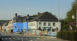
Junglinster (Luxembourgish: Jonglënster) is a commune in central Luxembourg, which draws its name from its principal town, Junglinster. It is one of six communes in the Luxembourg canton of Grevenmacher. The 18th-century St Martin's church is a national monument.
