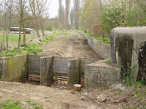
The Koningshooikt–Wavre Line, abbreviated to KW Line (French: Ligne KW; Dutch: KW-stelling) and often known as the Dyle Line after the Dijle (Dyle) river, was a 60 kilometres (37 mi)-long fortified line of defence prepared by the Belgian Army between Koningshooikt (Province of Antwerp) and Wavre (Province of Brabant) which was intended to protect Brussels from a possible German invasion. Construction on the KW Line began in September 1939 after World War II had begun but while Belgium itself remained a neutral state.[1] It was subsequently extended southwards from Wavre towards Namur (Province of Namur). The line itself consisted of bunkers, anti-tank ditches, and barricades including so-called Cointet-elements and played a key role in Allied strategy during the German invasion of Belgium in May 1940. However, its role in the actual fighting was ultimately minimal. In 2009 an inventory of surviving emplacements was begun.[2]
- ^ Jacobsen, Mark; Levine, Robert; Schwabe, William (1985). "Belgian policy". Contingency plans for war in Western Europe, 1920–1940. Santa Monica, CA: Rand. p. 130. CiteSeerX 10.1.1.904.7376. ISBN 0-8330-0661-4. OCLC 12215643.
- ^ www.kwlinie.be