This article needs additional citations for verification. (June 2014) |
Kabacan | |
|---|---|
| Municipality of Kabacan | |
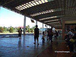
 Kabacan bus terminal | |
Nicknames:
| |
 Map of Cotabato with Kabacan highlighted | |
Location within the Philippines | |
| Coordinates: 7°07′N 124°49′E / 7.12°N 124.82°E | |
| Country | Philippines |
| Region | Soccsksargen |
| Province | Cotabato |
| District | 3rd district |
| Founded | August 18, 1947 |
| Barangays | 24 (see Barangays) |
| Government | |
| • Type | Sangguniang Bayan |
| • Mayor | Evangeline Pascua-Guzman |
| • Vice Mayor | Herlo P. Guzman, Jr |
| • Representative | Jose I. Tejada |
| • Electorate | 49,303 voters (2022) |
| Area | |
| • Total | 330.92 km2 (127.77 sq mi) |
| Elevation | 21 m (69 ft) |
| Highest elevation | 47 m (154 ft) |
| Lowest elevation | 8 m (26 ft) |
| Population (2020 census)[3] | |
| • Total | 77,164 |
| • Density | 230/km2 (600/sq mi) |
| • | 17,891 |
| Demonym | Kabaqueño/a |
| Economy | |
| • Income class | 1st municipal income class |
| • Poverty incidence | 29.19 |
| • Revenue | ₱ 343.2 million (2020) |
| • Assets | ₱ 592.1 million (2020) |
| • Expenditure | ₱ 300.7 million (2020) |
| • Liabilities | ₱ 124.7 million (2020) |
| Service provider | |
| • Electricity | Cotabato Electric Cooperative (COTELCO) |
| Time zone | UTC+8 (PST) |
| ZIP code | 9407 |
| PSGC | |
| IDD : area code | +63 (0)64 |
| Native languages | Hiligaynon Cebuano Maguindanao Ilianen Tagalog |
| Website | kabacan |
Kabacan officially the Municipality of Kabacan (Maguindanaon: Inged nu Kabakan, Jawi: ايڠد نو كباكن; Ilocano: Ili ti Kabacan; Hiligaynon: Banwa sang Kabacan; Cebuano: Lungsod sa Kabacan; Tagalog: Bayan ng Kabacan), is a 1st class municipality in the province of Cotabato, Philippines. According to the 2020 census, it has a population of 77,164 people.[3]
The town is predominantly composed of rice farms made possible by the influx of Ilocano-speaking people from northern Philippines. The University of Southern Mindanao is in Kabacan. It is strategically located between the cities of Cotabato and Davao from west to east and the cities of Cagayan de Oro and Iligan from the north and General Santos from the south.
- ^ Municipality of Kabacan | (DILG)
- ^ "2015 Census of Population, Report No. 3 – Population, Land Area, and Population Density" (PDF). Philippine Statistics Authority. Quezon City, Philippines. August 2016. ISSN 0117-1453. Archived (PDF) from the original on May 25, 2021. Retrieved July 16, 2021.
- ^ a b Census of Population (2020). "Region XII (Soccsksargen)". Total Population by Province, City, Municipality and Barangay. Philippine Statistics Authority. Retrieved July 8, 2021.
- ^ "PSA Releases the 2021 City and Municipal Level Poverty Estimates". Philippine Statistics Authority. April 2, 2024. Retrieved April 28, 2024.


