This article needs additional citations for verification. (March 2012) |
Kabala | |
|---|---|
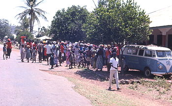
 The All Peoples Congress (APC) political rally in Kabala | |
| Coordinates: 9°35′N 11°33′W / 9.583°N 11.550°W | |
| Country | Sierra Leone |
| Province | Northern Province |
| District | Koinadugu District |
| Population (2010) | |
| • Total | 18,770 (estimate) |
| Time zone | UTC-5 (GMT) |

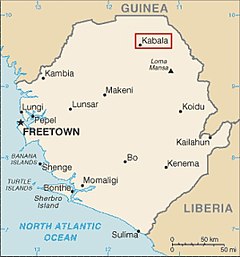
Kabala (Pular : 𞤑𞤢𞤦𞤢𞤤𞤢) is the capital and largest town of Koinadugu District in the Northern Province of Sierra Leone. Kabala is one of the main towns in Northern Sierra Leone and is set in a rural landscape, surrounded by mountains.[1][2]
Kabala lies approximately 85 miles (137 km) north-east of Makeni, the largest city in the north, and approximately 200 miles (320 km)[3] east of the capital Freetown. Kabala had a population of 14,108 in the 2004 census,[4] and a current estimate of 18,770 [5] The population of Kabala is predominantly Muslim, though there is a substantial Christian minority.
Kabala is an agricultural centre and lies on the far north of Sierra Leone, with close proximity to Kono District and the international border with Guinea . Kabala is one of the largest towns in Sierra Leone in total land area; but is less densely populated.
Kabala is one of the most ethnically diverse cities in Sierra Leone, with no single ethnic group forming a majority. Like the rest of Koinadugu District, the inhabitants of Kabala are largely from the Kuranko, Mandingo, Yalunka, Limba and Fula ethnic groups. As with most parts of Sierra Leone, the Krio language of the Sierra Leone Creole people is the most widely spoken language in Kabala.[6][7]
Sierra Leone's former president Ernest Bai Koroma celebrated the 2012 New Year in Kabala.[8] President Koroma held a townhall meeting at the Yogomaia Field in Kabala and attended new year church services at the Holy Martyrs Catholic Church in the town.[9]
- ^ "Rain doesn't deter people in mountainous Kabala | Amnesty's global human rights blog". Archived from the original on 2014-08-11. Retrieved 2012-09-10.
- ^ "Newsletter No. 14 - Community involvement in school water projects: Experience from post-conflict Sierra Leone - EENET". www.eenet.org.uk. Archived from the original on 2014-04-16.
- ^ "Newsletter No. 14 - Community involvement in school water projects: Experience from post-conflict Sierra Leone - EENET". www.eenet.org.uk. Archived from the original on 2014-04-16.
- ^ Sesay, Ibrahim Mohamed; Karama, Andrew A.; Ngobeh, Jinnah J. (November 2006), 2004 Population and Housing Census:Analytical Report on Population Distribution, Migration and Urbanisation in Sierra Leone (PDF), Sierra Leone: Statistics Sierra Leone, p. 73, retrieved 2008-07-25
- ^ [1][dead link]
- ^ "Krio Translation Services". Language9.com. Retrieved 20 May 2012.
- ^ Oyètádé, B. Akíntúndé; Fashole-Luke, Victor (15 February 2008). "Sierra Leone: Krio and the Quest for National Integration". Language and National Identity in Africa. Oxford: Oxford University Press. pp. 122–140. ISBN 978-0-19-928675-1.
- ^ "President Koroma greets 2012 in prayer at Kabala | Nazareth House Apostolate".
- ^ "Sierra Leone State House – the Republic of Sierra Leone State House".
