Kaeng Hang Maeo
แก่งหางแมว | |
|---|---|
 Forest in Kaeng Hang Maeo District | |
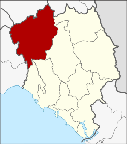
 District location in Chanthaburi province | |
| Coordinates: 13°0′30″N 101°54′18″E / 13.00833°N 101.90500°E | |
| Country | Thailand |
| Province | Chanthaburi |
| Seat | Kaeng Hang Maeo |
| Area | |
| • Total | 1,254.1 km2 (484.2 sq mi) |
| Population (2005) | |
| • Total | 36,453 |
| • Density | 29.1/km2 (75/sq mi) |
| Time zone | UTC+7 (ICT) |
| Postal code | 22160 |
| Geocode | 2208 |
Kaeng Hang Maeo (Thai: แก่งหางแมว, pronounced [kɛ̀ŋ hǎːŋ mɛ̄ːw]) is the northwesternmost district (amphoe) of Chanthaburi province, eastern Thailand.