Kafr 'Aqab
كفر عقب | |
|---|---|
| Arabic transcription(s) | |
| • Arabic | كفر عقب |
| • Latin | Kafr Aqab |
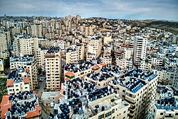
 Kfar 'Aqab, 2023 | |
Location of Kafr 'Aqab in East Jerusalem | |
| Coordinates: 31°52′33″N 35°13′11″E / 31.87583°N 35.21972°E | |
| Palestine grid | 171/143 |
| Governorate | Jerusalem |
| Government | |
| • Type | Municipality |
| Population (2017)[1] | |
| • Total | 24,724 |
| Name meaning | The village of the steep or mountain road[2] |
Kafr 'Aqab (Arabic: كفر عقب) is the northernmost Palestinian Arab neighborhood in East Jerusalem. It is part of the area annexed and included in municipal Jerusalem following its occupation by Israel in 1967. This area includes an additional approximate 64 km2 (25 sq mi)[a] of the West Bank, including territory which previously included 28 villages and areas of the Bethlehem and Beit Jala municipalities.[4][5] Although the Jerusalem Law did not use the term, the Israeli Supreme Court interpreted the law as an effective annexation of East Jerusalem.[6] The United Nations Security Council condemned the attempted change in status to Jerusalem and ruled the law "null and void" in United Nations Security Council Resolution 478.
Due to the Separation Wall effectively cutting the neighborhood off from the rest of Jerusalem, while no such barrier exists between this neighborhood and Ramallah and Al-Bireh, this neighborhood is practically part of the metropolitan area of Ramallah.
- ^ Jerusalem Municipality - Kafr Aqab Neighborhood Link
- ^ Palmer, 1881, p. 297
- ^ Lustick 1997, pp. 35, 37.
- ^ Holzman-Gazit, Yifat (2016). Land Expropriation in Israel: Law, Culture and Society. Routledge. ISBN 978-1-317-10836-8.
- ^ Schmidt, Yvonne (2008). Foundations of Civil and Political Rights in Israel and the Occupied Territories. GRIN Verlag. ISBN 978-3-638-94450-2.
- ^ Eyal Benvenisti (23 February 2012). The International Law of Occupation. OUP Oxford. pp. 205–. ISBN 978-0-19-958889-3.
Cite error: There are <ref group=lower-alpha> tags or {{efn}} templates on this page, but the references will not show without a {{reflist|group=lower-alpha}} template or {{notelist}} template (see the help page).
