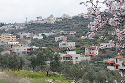
Kafr ad-Dik | |
|---|---|
| Arabic transcription(s) | |
| • Arabic | كفر الديك |
| • Latin | Kafr al-Deek (official) Kafar ad-Deek (unofficial) |
 Kafr ad-Dik, 2012 | |
Location of Kafr ad-Dik within Palestine | |
| Coordinates: 32°04′00″N 35°04′59″E / 32.06667°N 35.08306°E | |
| Palestine grid | 157/163 |
| State | |
| Governorate | Salfit |
| Government | |
| • Type | Municipality |
| Area | |
| • Total | 15,228 dunams (15.2 km2 or 5.9 sq mi) |
| Elevation | 375 m (1,230 ft) |
| Population (2017)[2] | |
| • Total | 5,551 |
| • Density | 370/km2 (950/sq mi) |
| Name meaning | "Village of the Rooster", "The Village"[3] |
Kafr ad-Dik (Arabic: كفر الديك) is a Palestinian town located 9.5 kilometers west of Salfit in the Salfit Governorate of Palestine, in the northern West Bank. According to the Palestinian Central Bureau of Statistics (PCBS), the town had a population of 5,551 in 2017.[2]
Approximately 70% of the families in Kafr ad-Dik are dependent on agriculture as the main source of income, while the remaining 30% work in the private and public sectors. The unemployment rate in the town is 60%.[4]
The town's total land area consists of 15,228 dunams of which 578 dunams are built-up. In the town's area, the archaeological ruins of Deir Samaan are located.
The Israeli settlements of Peduel and Alei Zahav, as well as nearby Israeli outposts, are built over 1,448 dunams of Kafr ad-Dik's land. As a result of the Interim Agreement on the West Bank and the Gaza Strip, the Palestinian National Authority controls the civil affairs of 1,953 dunums of Kafr ad-Dik's land (Area B), while 13,275 dunams are classified as Area C, which is under full Israeli control.[5]
- ^ Kafr ad Dik Town Profile, ARIJ, 2013, p. 4
- ^ a b Preliminary Results of the Population, Housing and Establishments Census, 2017 (PDF). Palestinian Central Bureau of Statistics (PCBS) (Report). State of Palestine. February 2018. pp. 64–82. Retrieved 2023-10-24.
- ^ Palmer, 1881, p. 230
- ^ More of Bruqin's and Kafr Ad dik's land are targeted by the Segregation Wall Archived 2007-05-28 at the Wayback Machine Applied Research Institute Jerusalem 2007-03-05.
- ^ House Demolitions warnings in Kafr ad Dik village Applied Research Institute Jerusalem 2007-05-07.
