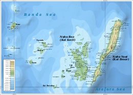
Native name: Kepulauan Kai | |
|---|---|
 The Kai Islands | |
 | |
| Geography | |
| Location | Southeast Asia |
| Coordinates | 5°45′S 132°44′E / 5.75°S 132.73°E |
| Total islands | 47 |
| Major islands | Kai Besar, Kai Kecil |
| Area | 1,252 km2 (483 sq mi) |
| Highest elevation | 890 m (2920 ft) |
| Administration | |
| Province | Maluku |
| Largest settlement | Tual |
| Additional information | |
| Time zone | |

The Kai Islands (also Kei Islands) of Indonesia are a group of islands in the southeastern part of the Maluku Islands, located in the province of Maluku.[1][2] The Moluccas have been known as the Spice Islands due to regionally specific plants such as nutmeg, mace, and cloves that originally intrigued the European nations of the 16th century.[3] The coastal zone of the islands are identified as a site of highest marine biodiversity importance in the Coral Triangle.[4]
- ^ "Indonesia: The Kai Islands (Kei Islands) « This Boundless World". thisboundlessworld.com.
- ^ Administrator. "Maluku Travel Information – Kei Islands – East-Indonesia.info". east-indonesia.info.
- ^ "Introducing Maluku". Lonely Planet. Retrieved 18 April 2015.
- ^ Asaad, Irawan; Lundquist, Carolyn J.; Erdmann, Mark V.; Costello, Mark J. (June 2018). "Delineating priority areas for marine biodiversity conservation in the Coral Triangle". Biological Conservation. 222 (2): 198–211.