This article needs additional citations for verification. (January 2022) |
Kaikorai Valley | |
|---|---|
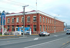
 The former Roslyn Woollen Mill buildings in Bradford | |
 | |
| Coordinates: 45°52′36″S 170°28′15″E / 45.8768°S 170.4708°E | |
| Country | New Zealand |
| City | Dunedin |
| Local authority | Dunedin City Council |
| Area | |
| • Land | 454 ha (1,122 acres) |
| Population (June 2024)[2] | |
• Total | 3,310 |
| Brockville | Wakari | |
|
|
City Rise | |
| Abbotsford | Green Island | Calton Hill |

Kaikorai Valley is a long broad valley which runs through the west of the New Zealand city of Dunedin, 5 kilometres (3.1 mi) to the west of the city centre. It is the valley of a small stream, the Kaikorai Stream, which runs from northeast to southwest down the length of the valley.
The valley provides a route into central Dunedin (Kaikorai Valley Road) which avoids the steep climb and descent over Lookout Point into Caversham, instead allowing for a gradual climb to the top of Stuart Street at Roslyn before a steep drop into the heart of the city. The valley contains several suburbs, largely isolated from the city centre by the ridge which forms the valley's eastern edge. This ridge was part of the crater wall of the long-extinct Dunedin Volcano.
The valley is largely occupied by light industrial and wholesale businesses. Much of the land to the west of the valley is semi-rural; the eastern wall contains residential properties.
The valley is home to three distinct suburbs: Kaikorai, Bradford, and Kenmure, while a fourth suburb, Burnside, lies at the valley's mouth, close to the junction of Kaikorai Valley Road and the Dunedin Southern Motorway, part of State Highway 1.
- ^ Cite error: The named reference
Areawas invoked but never defined (see the help page). - ^ "Aotearoa Data Explorer". Statistics New Zealand. Retrieved 26 October 2024.