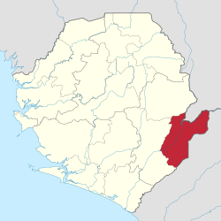
Kailahun District | |
|---|---|
 Location of Kailahun District in Sierra Leone | |
| Coordinates: 8°10′N 10°45′W / 8.167°N 10.750°W | |
| Country | Sierra Leone |
| Province | Eastern Province |
| Capital | Kailahun |
| Largest city | Kailahun |
| Government | |
| • Type | District Council |
| • Council Chairman | Sahr Ahmed Lamin[1] (SLPP) |
| Area | |
• Total | 3,859 km2 (1,490 sq mi) |
| Population | |
• Total | 525,372 |
| • Density | 140/km2 (350/sq mi) |
| Time zone | UTC-5 (Greenwich Mean Time) |
| HDI (2017) | 0.390[2] low · 8th |
Kailahun District is a district in the Eastern Province of Sierra Leone. Its capital and largest city is the town of Kailahun. The second most populous city in the district is Segbwema. Other major towns in Kailahun District include Koindu, Pendembu and Daru. As of the 2015 census, the district had a population of 525,372.[1] Kailahun District is subdivided into fourteen chiefdoms.
The District of Kailahun borders Kenema District to the west, Kono District to the north, the Republic of Liberia to the east, and the Republic of Guinea to the north. The border of the district with Guinea is formed by a section of the Moa River.[3] The total area of the district is 4,859 km2 (1,876 sq mi). The population of Kailahun District is largely from the Mende ethnic group, though there are other ethnic groups with significant population in the district, including among them the Kissi, Mandingo and the Fula.
The major economic activities in the district are farming, diamond mining and trade. The large majority of the people of Kailahun District are Muslims, though with a significant Christian minority.
Kailahun District is a political stronghold of the Sierra Leone People's Party (SLPP), the current ruling party in Sierra Leone. Since Sierra Leone"s Independence in 1961 to present, the overwhelming majority of the people of Kailahun Districts support the Sierra Leone People's Party (SLPP). Kailahun District is the birthplace of former Sierra Leone's president Ahmad Tejan Kabbah, who was born in the town of Pendembu.
- ^ a b "World Gazetteer: Search for a geographical entity". Archived from the original on 16 December 2012.
- ^ "Sub-national HDI - Area Database - Global Data Lab". hdi.globaldatalab.org. Retrieved 2018-09-13.
- ^ Katrina Manson and James Knight (2009). Sierra Leone. Bradt Travel Guides., page 275.