| Kakabeka Falls | |
|---|---|
 Kakabeka Falls | |
 | |
| Location | Oliver Paipoonge, Ontario, Canada |
| Coordinates | 48°24′10″N 89°37′32″W / 48.4029°N 89.6256°W |
| Type | Plunge[1] |
| Total height | 40 m (130 ft) |
| Number of drops | Two |
| Watercourse | Kaministiquia River |
| Average flow rate | 50 m3/s (1766 cu ft/s)[2] |

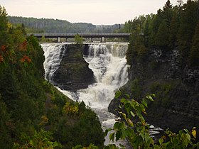
Kakabeka Falls (/ˌkækəˈbɛkə/) is a waterfall on the Kaministiquia River, located beside the village of Kakabeka Falls in the municipality of Oliver Paipoonge, Ontario, 30 km (19 mi) west of the city of Thunder Bay.
The falls have a drop of 40 m (130 ft),[3] cascading into a gorge carved out of the Precambrian Shield by meltwater following the last glacial maximum.[4] Because of its size and ease of access, it has been consequently nicknamed "the Niagara of the North".
The rock face of the falls and the escarpments along the gorge are composed primarily of unstable shale, and are eroding. These rocks host sensitive flora, and contain some of the oldest fossils in existence, some 1.6 billion years of age.[4] Due to the fragile rock, going into the gorge below the falls is prohibited.[5]
The name "Kakabeka" comes from the Ojibwe word gakaabikaa "waterfall over a cliff" ([ˈɡəkaːˈbɪkaː][help]).[6]
- ^ "Waterfalls of Ontario - Kakabeka Falls". Archived from the original on July 4, 2007.
- ^ Ontario Power Generation, Kakabeka Falls Total Outflow Archived October 13, 2007, at the Wayback Machine. Retrieved on September 22, 2007.
- ^ "Ontario Parks - Kakabeka Falls". Archived from the original on September 25, 2007.
- ^ a b "Thunder Bay Green Spaces - Kakabeka Falls Provincial Park". Retrieved September 21, 2007.
- ^ "Go Waterfalling - Kakabeka Falls". Retrieved September 21, 2007.
- ^ "Freelang Ojibwe Dictionary". Retrieved March 11, 2007.
