Kalat County
Persian: شهرستان کلات | |
|---|---|
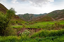
 Landscape near Spa Waterfall | |
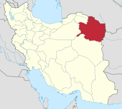
 Location of Kalat County in Razavi Khorasan Province (top right, purple) | |
 Location of Razavi Khorasan Province in Iran | |
| Coordinates: 36°51′N 59°52′E / 36.850°N 59.867°E[1] | |
| Country | Iran |
| Province | Razavi Khorasan |
| Capital | Kalat |
| Districts | Central, Hezarmasjed, Zavin |
| Area | |
| • Total | 3,503 km2 (1,353 sq mi) |
| Population (2016)[2] | |
| • Total | 36,237 |
| • Density | 10/km2 (27/sq mi) |
| Time zone | UTC+3:30 (IRST) |
| Kalat County at GEOnet Names Server | |
Kalat County (Persian: شهرستان کلات) is in Razavi Khorasan Province, Iran. Its capital is the city of Kalat.[3] Around half of the people of Kalat County are Tekke Turkmen; 35% are Kurdish and 15% are Persian.[4]
- ^ OpenStreetMap contributors (30 April 2023). "Kalat County" (Map). OpenStreetMap (in Persian). Retrieved 30 April 2023.
- ^ Cite error: The named reference
2016 censuswas invoked but never defined (see the help page). - ^ Aref, Mohammad Reza (18 December 1381). "Letter of approval regarding divisional reforms in Khorasan Province (Zavin District, Kalat County, Central District)". Laws and Regulations Portal of the Islamic Republic of Iran (in Persian). Ministry of Interior, Political-Defense Commission of the Cabinet of Ministers. Archived from the original on 7 January 2024. Retrieved 7 January 2024.
- ^ Khosravi, Mohammad Reza (1367). Kalat Naderi (in Persian). Astan Quds Razavi Publishing House.