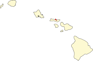
Kalawao County | |
|---|---|
 Kalaupapa peninsula | |
 Location within the U.S. state of Hawaii | |
 Hawaii's location within the U.S. | |
| Coordinates: 21°11′49″N 156°58′02″W / 21.196944444444°N 156.96722222222°W | |
| Country | |
| State | |
| Founded | 1905 |
| Named for | Kalawao |
| Seat | none (administered by Hawaii Dept. of Health) |
| Largest community | Kalaupapa |
| Area | |
| • Total | 53 sq mi (140 km2) |
| • Land | 12 sq mi (30 km2) |
| • Water | 41 sq mi (110 km2) 77.3% |
| Population (2020) | |
| • Total | 82 |
| • Density | 1.5/sq mi (0.60/km2) |
| Time zone | UTC−10 (Hawaii–Aleutian) |
| Congressional district | 2nd |
Kalawao County (Hawaiian: Kalana o Kalawao) is a county in the U.S. state of Hawaii.[1] It is the smallest county in the 50 states by land area and the second-smallest county by population, after Loving County, Texas.[2] The county encompasses the Kalaupapa or Makanalua Peninsula, on the north coast of the island of Molokaʻi. The small peninsula is isolated from the rest of Molokaʻi by cliffs over a quarter-mile high; the only land access is a mule trail.[3]
Because of the small population (82 as of the 2020 United States Census[4]), Kalawao County does not have the same functions as other Hawaii counties. Instead, it is a judicial district of Maui County, which includes the rest of the island of Molokaʻi. The county has no elected government.[5]
It was developed and used from 1866 to 1969 for settlements for treatment of quarantined persons with Hansen's disease (leprosy).[6]
- ^ Voss, Oscar (2012). "Is Kalawao County, on the north shore of Molokai, really a separate county?". Retrieved January 25, 2015.
- ^ "2020 Population and Housing State Data". United States Census Bureau. Retrieved August 12, 2021.
- ^ "Kalaupapa National Historical Park". National Park Service. Retrieved August 11, 2022.
- ^ "Tableau".
- ^ "Kalawao County | Office of Hawaiian Affairs" (PDF). Office of Hawaiian Affairs. Archived (PDF) from the original on August 11, 2022. Retrieved August 11, 2022.
Kalawao County has no county government; a sheriff is appointed by the Hawai'i Department of Health (DOH). The HRS Chapter 326, Sections 326-1-326-40 Hansen's Disease detail topics including patient treatment, care, services, expenses, and privacy; general excise, income, and real property tax exemptions; employment, compensation, and pensions; Kalaupapa store; fishing laws exemption; and Damien Memorial Chapel.
- ^ "When the Last Patient Dies". The Atlantic. May 27, 2015. Archived from the original on August 11, 2022. Retrieved August 11, 2022.
