Kamilaroi Highway | |
|---|---|
 | |
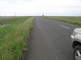
| A small mirage on Kamilaroi Highway near Cryon | |
 | |
| General information | |
| Type | Highway |
| Length | 605 km (376 mi)[1] |
| Gazetted | August 1928 (as Main Road 127)[2] July 1933 (as Trunk Rad 72)[3] February 1999 (as State Highway 29)[4] |
| Route number(s) |
|
| Former route number | Entire route |
| Major junctions | |
| Northwest end | Bourke, New South Wales |
| Southeast end | Willow Tree, New South Wales |
| Location(s) | |
| Major settlements | Brewarrina, Walgett, Burren Junction, Wee Waa, Narrabri, Boggabri, Gunnedah, Quirindi |
| Highway system | |
| ---- | |
Kamilaroi Highway is a 605-kilometre (376 mi)[1] state highway located in the north-western region of New South Wales, Australia, and links Bourke via Walgett and Narrabri to Willow Tree. The highway is named after the Kamilaroi Indigenous Australian people who live in the area.[citation needed]
- ^ a b "Kamilaroi Highway" (Map). Google Maps. Retrieved 8 March 2023.
- ^ "Main Roads Act, 1924-1927". Government Gazette of the State of New South Wales. No. 110. 17 August 1928. pp. 3814–20. Archived from the original on 3 August 2022. Retrieved 1 August 2022 – via National Library of Australia.
- ^ "Main Roads Act, 1924-1931". Government Gazette of the State of New South Wales. No. 119. National Library of Australia. 4 August 1933. p. 2882. Archived from the original on 17 October 2022. Retrieved 17 October 2022.
- ^ "Roads Act". Government Gazette of the State of New South Wales. No. 19. National Library of Australia. 12 February 1999. p. 686. Archived from the original on 17 October 2022. Retrieved 19 October 2022.