Kamouraska | |
|---|---|
 Aerial view of Kamouraska | |
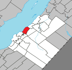
 Location within Kamouraska RCM | |
| Coordinates: 47°34′N 69°52′W / 47.567°N 69.867°W[1] | |
| Country | |
| Province | |
| Region | Bas-Saint-Laurent |
| RCM | Kamouraska |
| Constituted | April 25, 1987 |
| Named for | Kamouraska River[2] |
| Government | |
| • Mayor | Anik Corminboeuf |
| • Federal riding | Montmagny—L'Islet— Kamouraska—Rivière-du-Loup |
| • Prov. riding | Côte-du-Sud |
| Area | |
• Total | 145.50 km2 (56.18 sq mi) |
| • Land | 44.07 km2 (17.02 sq mi) |
| Population | |
• Total | 607 |
| • Density | 13.8/km2 (36/sq mi) |
| • Pop 2016-2021 | |
| • Dwellings | 393 |
| Time zone | UTC−5 (EST) |
| • Summer (DST) | UTC−4 (EDT) |
| Postal code(s) | |
| Area code(s) | 418 and 581 |
| Highways | |
| Website | www |
Kamouraska is a municipality on the south shore of the Saint Lawrence River in the Bas-Saint-Laurent region of Quebec, Canada. It is part of the Regional County Municipality of Kamouraska. It has been named one of the top 20 most beautiful villages in the province of Quebec, and the municipality is a member of the Most Beautiful Villages of Quebec Association.
The name "Kamouraska" comes from an Algonquin word meaning "where rushes grow at the water's edge".
- ^ Cite error: The named reference
toponymiewas invoked but never defined (see the help page). - ^ "Fiche descriptive".
- ^ a b Cite error: The named reference
mamrotwas invoked but never defined (see the help page). - ^ a b Cite error: The named reference
cp2021was invoked but never defined (see the help page).

