Kampong Thom
កំពង់ធំ | |
|---|---|
| Kampong Thom Province ខេត្តកំពង់ធំ | |
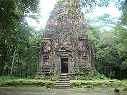
 Sambor Prei Kuk, a UNESCO World Heritage Site and the symbol of the province | |
 Map of Cambodia highlighting Kampong Thom | |
| Coordinates: 12°42′N 104°53′E / 12.700°N 104.883°E | |
| Country | |
| Provincial status | 1907 |
| Capital | Kampong Thom |
| Subdivisions | 1 municipality; 8 districts |
| Government | |
| • Governor | Ngoun Ratanak (CPP) |
| • National Assembly | 6 / 125
|
| Area | |
| • Total | 13,814 km2 (5,334 sq mi) |
| • Rank | 2nd |
| Population (2019)[1] | |
| • Total | |
| • Rank | 11th |
| • Density | 49/km2 (130/sq mi) |
| • Rank | 17th |
| Time zone | UTC+07:00 (ICT) |
| Dialing code | +855 |
| ISO 3166 code | KH-6 |
| Website | www |
Kampong Thom (Khmer: កំពង់ធំ, UNGEGN: Kâmpóng Thum [kɑmpɔŋ tʰom]; lit. 'Great Port') is a province (khaet) of Cambodia. It borders the provinces of Siem Reap to the northwest, Preah Vihear to the north, Stung Treng to the northeast, Kratie to the east, Kampong Cham and Kampong Chhnang to the south, and the Tonle Sap to the west.
The provincial capital is Stung Saen, a town of approximately 30,000 people on the banks of the Stung Sen River.
Kampong Thom is Cambodia's second largest province by area. There are a number of significant Angkorian sites in the area, including Prasat Sambor Prei Kuk and Prasat Andet temples. As one of the nine provinces bordering Tonle Sap Lake, Kampong Thom is part of the Tonlé Sap Biosphere Reserve.[2]
- ^ "General Population Census of the Kingdom of Cambodia 2019 – Final Results" (PDF). National Institute of Statistics. Ministry of Planning. 26 January 2021. Retrieved 3 February 2021.
- ^ "Tonle Sap Biosphere Reserve Environmental Information Database - Home". Archived from the original on 5 September 2008. Retrieved 12 February 2020.
