| Kander | |
|---|---|
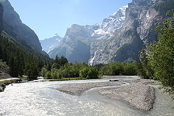
 The Kander in the Gasterntal | |
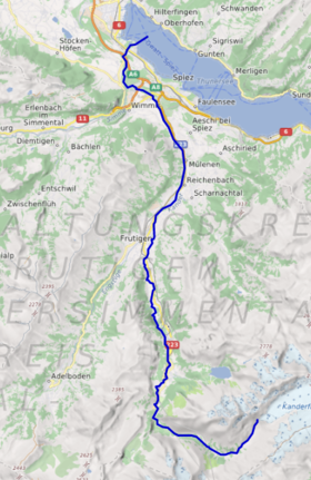
 Course of the Kander | |
| Location | |
| Country | Switzerland |
| State | Bern |
| Physical characteristics | |
| Source | |
| • location | Kander Neve, Switzerland |
| • coordinates | 46°27′53″N 07°45′54″E / 46.46472°N 7.76500°E |
| • elevation | 2,301 m (7,549 ft) |
| Mouth | |
• location | Lake Thun, Switzerland |
• coordinates | 46°43′02″N 07°38′22″E / 46.71722°N 7.63944°E |
• elevation | 558 m (1,831 ft) |
| Length | 44 km (27 mi) |
| Discharge | |
| • location | Lake Thun/Aare |
| Basin features | |
| Progression | Lake Thun→ Aare→ Rhine→ North Sea |
| Tributaries | |
| • left | Engstlige, Simme |
| • right | Öschibach, Chiene, Suld |
The Kander is a river in Switzerland. It is 44 kilometres (27 mi) long and has a watershed of 1,126 square kilometres (435 sq mi). Originally a tributary of the Aare, with a confluence downstream of the city of Thun, since 1714 it flows into Lake Thun upstream of the city.
The drainage water from the Kander Neve (glacier) in the middle of the Bernese Alps at an altitude of 2,301 m (7,549 ft) flows through the Gasteretal westward. 3 kilometres (1.9 mi) south of Kandersteg it turns to north into the larger Kandertal. After 14 kilometres (8.7 mi) it converges in Frutigen with the Engstlige from the left, its second major tributary. The Engstligental with Adelboden at its south end, runs more or less parallel to the Kandertal before they converge into the Frutigtal. Continuing northwards, the Frutigtal makes a long bend to the west in order to get around the Niesen. Between Spiez and Reutigen it converges with the Simme from the left, its major tributary, and turns to the north again and flows into the Lake of Thun after a break through a hill, which used to prevent it flowing into the lake until 1714. Here the river crosses the A6 motorway.