Kangasniemi | |
|---|---|
Municipality | |
| Kangasniemen kunta Kangasniemi kommun | |
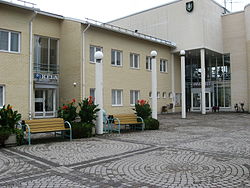
 Kangasniemi town hall | |
 Location of Kangasniemi in Finland | |
| Coordinates: 61°59.4′N 026°38.5′E / 61.9900°N 26.6417°E | |
| Country | |
| Region | Southern Savonia |
| Sub-region | Mikkeli sub-region |
| Charter | 1867 |
| Government | |
| • Municipal manager | Kimmo Kainulainen |
| Area (2018-01-01)[1] | |
• Total | 1,326.75 km2 (512.26 sq mi) |
| • Land | 1,068.89 km2 (412.70 sq mi) |
| • Water | 256.86 km2 (99.17 sq mi) |
| • Rank | 73rd largest in Finland |
| Population (2024-10-31)[2] | |
• Total | 5,084 |
| • Rank | 164th largest in Finland |
| • Density | 4.76/km2 (12.3/sq mi) |
| Population by native language | |
| • Finnish | 97% (official) |
| • Swedish | 0.2% |
| • Others | 2.8% |
| Population by age | |
| • 0 to 14 | 11.8% |
| • 15 to 64 | 51.5% |
| • 65 or older | 36.7% |
| Time zone | UTC+02:00 (EET) |
| • Summer (DST) | UTC+03:00 (EEST) |
| Website | www.kangasniemi.fi |
Kangasniemi is a municipality in the Southern Savonia region, Finland. The municipality has a population of 5,084 (31 October 2024)[2] and covers an area of 1,326.75 square kilometres (512.26 sq mi) of which 256.86 km2 (99.17 sq mi) is water.[1] The population density is 4.76 inhabitants per square kilometre (12.3/sq mi).
Kangasniemi is located on the Finnish national road 13, 50 km (31 mi) northwest of Mikkeli and 63 km (39 mi) southeast of Jyväskylä. Distance to the national capital, Helsinki is 250 km (160 mi). Its neighbour municipalities are Hankasalmi, Hirvensalmi, Joutsa, Mikkeli, Pieksämäki and Toivakka.
There are almost 3600 (May 2014) summer houses, and summer guests redouble the number of inhabitants during the summer months.
The municipality is unilingually Finnish.
- ^ a b "Area of Finnish Municipalities 1.1.2018" (PDF). National Land Survey of Finland. Retrieved 30 January 2018.
- ^ a b c "Finland's preliminary population figure was 5,635,560 at the end of October 2024". Population structure. Statistics Finland. 19 November 2024. ISSN 1797-5395. Retrieved 22 November 2024.
- ^ "Population according to age (1-year) and sex by area and the regional division of each statistical reference year, 2003–2020". StatFin. Statistics Finland. Retrieved 2 May 2021.
- ^ a b "Luettelo kuntien ja seurakuntien tuloveroprosenteista vuonna 2023". Tax Administration of Finland. 14 November 2022. Retrieved 7 May 2023.
