Kangilinnguit
Grønnedal | |
|---|---|
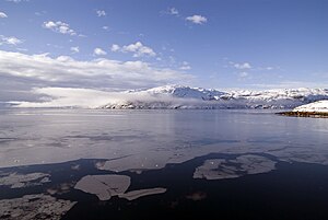
 Fjord icefloes, view from Kangilinnguit | |
| Coordinates: 61°14′00″N 48°05′55″W / 61.23333°N 48.09861°W | |
| State | |
| Constituent country | |
| Municipality | |
| Population (2010) | |
| • Total | 160 |
| Time zone | UTC-03 |
| Postal Code | 3905 Nuussuaq |
Kangilinnguit Heliport | |||||||||||
|---|---|---|---|---|---|---|---|---|---|---|---|
| Summary | |||||||||||
| Airport type | Military | ||||||||||
| Elevation AMSL | 95 ft / 29 m | ||||||||||
 | |||||||||||
| Helipads | |||||||||||
| |||||||||||

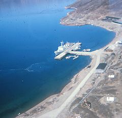
Kangilinnguit or Kangilínguit, formerly Grønnedal Greenlandic pronunciation: [kaŋiliŋːuit], is a settlement and location of a former naval base in Greenland's Sermersooq municipality, located at the mouth of Arsuk Fjord[1] in southwestern Greenland. The settlement had 160 inhabitants in 2010,[2] most of whom are Danish Navy personnel, attached to Island Command Greenland headquarters.[3]
For the former U.S. Naval Operating Facility there, see Bluie West Seven.
- ^ "Greenland and the Arctic". By Etain O'Carroll and Mark Elliott. Lonely Planet 2005. ISBN 1-74059-095-3.
- ^ Statistics Greenland Archived 2011-08-12 at the Wayback Machine (in Danish)
- ^ Danish Agency for Science, Technology and Innovation Archived 2007-06-06 at the Wayback Machine
