| Kanjirapuzha Dam | |
|---|---|
 Kanjirapuzha Dam | |
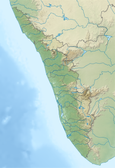
| Location | Mannarkkad, Palakkad District, Kerala, India |
| Coordinates | 10°59.2′N 76°33.03′E / 10.9867°N 76.55050°E |
| Construction began | 1961 |
| Opening date | 1995 |
| Operator(s) | Irrigation Department |
| Dam and spillways | |
| Impounds | Kakki tributary |
| Height | 30.78 m (101.0 ft) |
| Length | 2,127 m (6,978 ft) |
| Reservoir | |
| Creates | Kanjirapuzha |
| Total capacity | 70.83 MCM |
| Catchment area | 7,000 hectares (17,000 acres) |
| Surface area | 465 hectares (1,150 acres) |
| Normal elevation | 97.54 m (320.0 ft) |
The Kanjirapuzha Dam, a masonry earth dam built for providing irrigation to a Cultural Command Area (CCA) of 9,713 hectares (24,000 acres), is located in the Palakkad district in the Indian state of Kerala.[1] The reservoir, which has three islands within it, also has an established commercial fisheries development programme operated by the Fisheries Department.[2]
Construction of the dam, including the irrigation system, was started in 1961 at an initial cost of Rs. 3.65 crores (1954 price level) which was revised to Rs. 101.19 crores (1970 price level). The irrigation command was partially developed in 1980 with a total CCA of 8,465 hectares (20,920 acres). To complete the irrigation development in the entire command a new scheme titled "Extension, Renovation and Modernisation (ERM) Irrigation Project" under the Accelerated Irrigation Benefit Programme (AIBP) initiated by the Prime Minister of India, was approved by the Planning Commission in the year 2008 for an estimated cost of Rs 30.0 crore, to cover balance CCA of 1,247 hectare.[3]
- ^ "Salient Features of Kanhira Puzha (Id) Dam". Water Resources Information System of India, Government of India. Retrieved 14 May 2016.
- ^ "Places Of Tourist Interest". National Informatics Center. Archived from the original on 10 May 2016. Retrieved 14 May 2016.
- ^ "Kanhirapuzha Major Irrigation Project JI02675". Water Resources Information System of India, Government of India. Retrieved 14 May 2016.

