You can help expand this article with text translated from the corresponding article in Finnish. (June 2023) Click [show] for important translation instructions.
|
Kannus | |
|---|---|
Town | |
| Kannuksen kaupunki Kannus stad | |
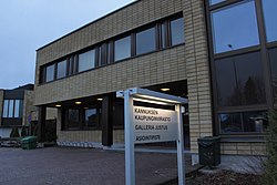
 Kannus Town Hall | |
 Location of Kannus in Finland | |
| Coordinates: 63°54′N 023°55′E / 63.900°N 23.917°E | |
| Country | |
| Region | Central Ostrobothnia |
| Sub-region | Kokkola sub-region |
| Charter | 1859 |
| Government | |
| • Town manager | Jussi Niinistö |
| Area (2018-01-01)[1] | |
• Total | 470.65 km2 (181.72 sq mi) |
| • Land | 468.04 km2 (180.71 sq mi) |
| • Water | 2.41 km2 (0.93 sq mi) |
| • Rank | 184th largest in Finland |
| Population (2024-10-31)[2] | |
• Total | 5,260 |
| • Rank | 162nd largest in Finland |
| • Density | 11.24/km2 (29.1/sq mi) |
| Population by native language | |
| • Finnish | 96.9% (official) |
| • Swedish | 0.4% |
| • Others | 2.8% |
| Population by age | |
| • 0 to 14 | 18.1% |
| • 15 to 64 | 57.5% |
| • 65 or older | 24.4% |
| Time zone | UTC+02:00 (EET) |
| • Summer (DST) | UTC+03:00 (EEST) |
| Website | kannus |
Kannus is a town and municipality of Finland. It is situated in the province of Western Finland and is part of the Central Ostrobothnia region. The municipality has a population of 5,260 (31 October 2024)[2] and covers an area of 470.65 square kilometres (181.72 sq mi), of which 2.41 km2 (0.93 sq mi) is water.[1] The population density is 11.24 inhabitants per square kilometre (29.1/sq mi). The municipality is unilingually Finnish. Neighbour municipalities are Kalajoki, Kokkola, Sievi and Toholampi.
The area of Kannus was long inhabited by Sámi. This is also indicated by the name of the town, which means Sámi witch drum.[5] The hammer of the witch drum in the coat of arms of the town also refers to the same.[6]
- ^ a b "Area of Finnish Municipalities 1.1.2018" (PDF). National Land Survey of Finland. Retrieved 30 January 2018.
- ^ a b c "Finland's preliminary population figure was 5,635,560 at the end of October 2024". Population structure. Statistics Finland. 19 November 2024. ISSN 1797-5395. Retrieved 22 November 2024.
- ^ "Population according to age (1-year) and sex by area and the regional division of each statistical reference year, 2003–2020". StatFin. Statistics Finland. Retrieved 2 May 2021.
- ^ a b "Luettelo kuntien ja seurakuntien tuloveroprosenteista vuonna 2023". Tax Administration of Finland. 14 November 2022. Retrieved 7 May 2023.
- ^ Raija Karlsson & Kari-Pekka Karlsson (1986). Finlandia, Otavan Maammekirja 7 (in Finnish). Helsinki: Otava. p. 73. ISBN 951-1-08930-7.
- ^ "Hallinto ja päätöksenteko: Kannusinfo" (in Finnish). Town of Kannus. Retrieved 21 June 2022.
