Kantishna, Alaska | |
|---|---|
 Kantishna | |
 | |
| Coordinates: 63°31′31″N 150°57′29″W / 63.52528°N 150.95806°W | |
| Country | United States |
| State | Alaska |
| Borough | Denali |
| Government | |
| • Borough mayor | Clay Walker[1] |
| • State senator | Click Bishop (R) |
| • State rep. | Dave Talerico (R) |
| Elevation | 1,696 ft (517 m) |
| Time zone | UTC-9 (Alaska (AKST)) |
| • Summer (DST) | UTC-8 (AKDT) |
| ZIP codes | Kantishna is one of the sparsely-populated communities in Alaska that do not have a zip code. |
| GNIS feature ID | 1404435[2] |
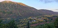
Kantishna is an unincorporated community in Denali Borough, Alaska, United States, within Denali National Park and Preserve.[3] Founded as a gold mining camp in 1905, it endured longer than similar communities in the area, having been constructed nearest to the source of the gold. It lies in the Kantishna Hills at the junction of Eureka Creek and Moose Creek, 3 mi (5 km) northwest of Wonder Lake, and near the mouth of the Kantishna River. Although the community was once also called "Eureka", the Board on Geographic Names officially ruled in favor of "Kantishna" in 1944, the name given to the post office that was built at the site in 1905. Its elevation is 1,696 feet (517 m).[2]
- ^ 2015 Alaska Municipal Officials Directory. Juneau: Alaska Municipal League. 2015. p. 5.
- ^ a b "Kantishna, Alaska". Geographic Names Information System. United States Geological Survey, United States Department of the Interior.
- ^ AK: Best of Summer, Alaska Public Radio, September 13, 2008. Accessed 2008-09-13.
