Kaokoland | |||||||||
|---|---|---|---|---|---|---|---|---|---|
| 1980–1989 | |||||||||
|
Flag | |||||||||
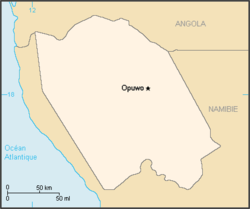
 Map of the bantustan. | |||||||||
| Status | Bantustan de facto administered by Hereroland | ||||||||
| Capital | Opuwo | ||||||||
| History | |||||||||
• Established | 1980 | ||||||||
• Re-integrated into Namibia | May 1989 | ||||||||
| Currency | South African rand | ||||||||
| |||||||||

Kaokoland was an administrative unit and a bantustan in northern South West Africa (now Namibia). Established in 1980 during the apartheid era, it was intended to be a self-governing homeland of the Ovahimba, but an actual government was never established, and the territory was administered by the leaders of Hereroland. Like other homelands in South West Africa, the Kaokoland bantustan was abolished in May 1989, at the beginning of the transition of Namibia towards independence.
"Kaokoland" remains as an informal name for the geographic area, while the political unit of administration since 1990 has been Kunene Region. The area is in the Kaokoveld ecoregion. The area is one of the wildest and least populated areas in Namibia, with a population density of one person every 2 km2 (1/4 of the national average). The most represented ethnic group is the Himba people, who account for about 5,000 of the overall 16,000 inhabitants of Kaokoland. The main settlement in Kaokoland was the city of Opuwo.
