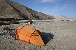
| Karakash River | |
|---|---|
 | |
| Location | |
| Country | China |
| Autonomous region | Xinjiang |
| Physical characteristics | |
| Source | Karakoram range |
| • location | Aksai Chin |
| • coordinates | 34°54′26″N 78°28′22″E / 34.907349°N 78.472665°E |
| • elevation | 19,000 feet (5,800 m) |
| Mouth | |
• location | Hotan River |
• coordinates | 38°05′09″N 80°33′41″E / 38.0858°N 80.5613°E |
| Length | 740 km (460 mi) |
| Basin size | 19,983 km2 (7,715 sq mi) |
| Discharge | |
| • average | 69.7 m3/s (2,460 cu ft/s) |
| Basin features | |
| Progression | Hotan→ Tarim→ Taitema Lake |
| Landmarks | Xaidulla, Hotan |
The Karakash or Black Jade River, also spelled Karakax (Chinese: 喀拉喀什河; pinyin: Kālākāshí Hé, [قاراقاش دەرياسى] Error: {{Langx}}: invalid parameter: |lat= (help), Қарақаш Дәряси), is a river in the Xinjiang autonomous region of the People's Republic of China that originates in Aksai Chin. It passes through the historical settlement of Xaidulla (Shahidulla or Saitula) and passes by the city of Khotan (Hotan) to flow northeast in the Tarim Basin. It merges with the Yurungkash River, the combined river taking the name Hotan River and flowing into the Tarim River.[1]
- ^ Malhotra, Iqbal Chand (2020-11-01). Red Fear: The China Threat. Bloomsbury Publishing. ISBN 978-93-89867-59-6.
