This article relies largely or entirely on a single source. (January 2020) |
| Karamana River Karamanayar | |
|---|---|
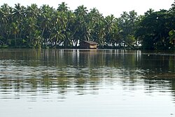
 Karamana river at Kovalam | |
| Etymology | Named after Karamana, a suburb of Thiruvananthapuram |
| Native name | കരമനയാർ (Malayalam) |
| Location | |
| Country | |
| State | Kerala |
| District | Thiruvananthapuram |
| Physical characteristics | |
| Source | Western Ghats |
| • location | Agastyarkoodam |
| Mouth | Arabian Sea |
• location | Kovalam |
• coordinates | 8°25′33″N 76°57′30″E / 8.42583°N 76.95833°E |
| Length | 66 km (41 mi) |
Karamana is a river flowing through the city of Thiruvananthapuram in Kerala, India. The river starts near the southern tip of the Western Ghats(Sahyadri Mountains) at Agastyar Koodam. The river flows 66 km westward and merges with the Arabian Sea at Panathura near Kovalam.[1] The river gets its name from Karamana, a suburb of Thiruvananthapuram city, through which it flows.
The catchment area is mostly forested, command area is under mixed dry land crops such as coconut, tapioca, pepper, plantain, rice, etc. [2]

- ^ Nair, Achuthsankar S (8 November 2012). "And Quiet Flows The Karamana: The river wild". The Hindu. Retrieved 18 January 2020.
- ^ Keralapages.org

