This article needs additional citations for verification. (April 2016) |
Karlstein am Main | |
|---|---|
 Old town hall in Dettingen | |
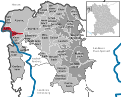
Location of Karlstein am Main within Aschaffenburg district  | |
| Coordinates: 50°2′56″N 9°1′6″E / 50.04889°N 9.01833°E | |
| Country | Germany |
| State | Bavaria |
| Admin. region | Lower Franconia |
| District | Aschaffenburg |
| Subdivisions | 2 Ortsteile |
| Government | |
| • Mayor (2023–29) | Peter Kreß[1] |
| Area | |
| • Total | 12.68 km2 (4.90 sq mi) |
| Elevation | 110 m (360 ft) |
| Population (2023-12-31)[2] | |
| • Total | 8,125 |
| • Density | 640/km2 (1,700/sq mi) |
| Time zone | UTC+01:00 (CET) |
| • Summer (DST) | UTC+02:00 (CEST) |
| Postal codes | 63791 |
| Dialling codes | 06188 |
| Vehicle registration | AB |
| Website | www.karlstein.de |
Karlstein am Main (officially Karlstein a. Main) is a municipality in the Aschaffenburg district in the Regierungsbezirk of Lower Franconia (Unterfranken) in Bavaria, Germany. It is the westernmost settlement in Bavaria. Karlstein's Ortsteile (constituent villages) are Dettingen and Großwelzheim, the former being notable as the site of the Battle of Dettingen during the War of the Austrian Succession. In the 20th century, the town was the site of the, now decommissioned, Großwelzheim Nuclear Power Plant.
- ^ Liste der ersten Bürgermeister/Oberbürgermeister in kreisangehörigen Gemeinden, Bayerisches Landesamt für Statistik. Retrieved 5 September 2023.
- ^ Genesis Online-Datenbank des Bayerischen Landesamtes für Statistik Tabelle 12411-003r Fortschreibung des Bevölkerungsstandes: Gemeinden, Stichtag (Einwohnerzahlen auf Grundlage des Zensus 2011).


