| Karnaphuli River | |
|---|---|
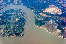
 Aerial view of the Karnaphuli River estuary | |
 | |
| Location | |
| Countries | India and Bangladesh |
| Cities | Chittagong |
| Physical characteristics | |
| Source | |
| • location | Saithah, Mizoram, India |
| Mouth | |
• location | Bay of Bengal |
| Length | 270 kilometres (170 mi) |


The Karnaphuli River (Bengali: কর্ণফুলি Kôrnophuli; also spelt Karnafuli[1] and Khawthlangtuipui[2] in Mizo, meaning "western river" and Borgang in Chakma, meaning "Big River") is the largest and most important river in Chittagong and the Chittagong Hill Tracts. It is a 667-metre (2,188 ft) wide river in the south-eastern part of Bangladesh. Originating from the Saithah village of Mamit district in Mizoram, India, it flows 270 kilometres (170 mi) southwest through Chattogram Hill Tracts and Chattogram into the Bay of Bengal. It is the fastest flowing river in Bangladesh, after the Padma. It is said to "represent the drainage system of the whole south-western part of Mizoram."[3] Principal tributaries include the Kawrpui River or Thega River, Tuichawng River and Phairuang River. A large hydroelectric power plant was built on the Karnaphuli in the Kaptai region in the 1960s. The mouth of the river hosts the Port of Chattogram, the largest and busiest seaport of Bangladesh.
- ^ Mesbah-us-Saleheen and Sifatul Quader Chowdhury (2012), "Karnafuli River", in Sirajul Islam and Ahmed A. Jamal (ed.), Banglapedia: National Encyclopedia of Bangladesh (Second ed.), Asiatic Society of Bangladesh
- ^ Tan, Khee Giap; Low, Linda; Tan, Kong Yam; Rao, Vittal Kartik (31 December 2013). Annual Analysis Of Competitiveness, Simulation Studies And Development Perspective For 35 States And Federal Territories Of India: 2000-2010. World Scientific. p. 676. ISBN 978-981-4579-49-0.
- ^ Pachuau, Rintluanga (1 January 2009). Mizoram: A Study in Comprehensive Geography. Northern Book Centre. p. 40. ISBN 978-81-7211-264-6. Retrieved 8 August 2012.