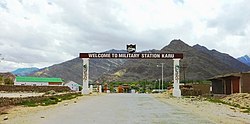
Kharu
Karu | |
|---|---|
Town | |
 Military Station at Karu | |
| Coordinates: 33°56′31″N 77°45′51″E / 33.9419°N 77.7643°E | |
| Country | India |
| Union Territory | Ladakh |
| District | Leh |
| Tehsil | Kharu[1] |
| Languages | |
| • Official | Ladakhi, English |
| Time zone | UTC+5:30 (IST) |
| Census code | 892 |
Kharu[2] (Wylie: mkhar bu, THL: khar bu) also spelt Karu, is a town, subdivision, tehsil, block, tourist station and military base on the bank of Indus River in the Leh district of Union territory of Ladakh in India. It is located 34 km southeast of Leh on Leh-Manali Highway and under-construction Bhanupli–Leh line.[2][3][4] [5][6] Karu is one of the important railway station and military's railway logistics hub on the under construction Bhanupli–Leh line of Indian Railway.[7] Karu is an important transit point where several strategic and important road arterial and feeder routes of India-China Border Roads meet, such as Leh-Manali Highway, Leh-Nyoma road, Hamis-Karo-Pangong Tso road, etc.
- ^ "Villages | District Leh, Union Territory of Ladakh | India".
- ^ a b Subdivisions and blocks of Leh, Leh dustrict website.
- ^ Rashid, Hakeem Irfan. "Sombre Hemis fest in Ladakh amid covid, Chinese incursion". The Economic Times. Retrieved 20 August 2020.
- ^ Rashid, Hakeem Irfan. "Early signs of incursion by Chinese in August 2019: A local from Durbok". The Economic Times. Retrieved 20 August 2020.
- ^ "China deploys troops all along 4,000-km LAC". Rediff. Retrieved 20 August 2020.
- ^ "Chinese Army build-up from Ladakh to Arunachal, Indian Army increases troop deployment all along LAC". ANI News. Retrieved 20 August 2020.
- ^ "डीपीआर तैयार: सेना के लिए चीन सीमा तक अलग से बिछेगा 13 किलोमीटर रेल ट्रैक". Amar Ujala. Retrieved 14 September 2022.

