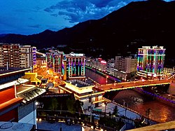
Karub District
卡若区 • མཁར་རོ་ཆུས། Karuo, Kharro, Chamdo | |
|---|---|
 | |
 Location of Karub District within Tibet Autonomous Region | |
| Coordinates: 32°16′34″N 97°15′41″E / 32.27611°N 97.26139°E | |
| Country | China |
| Autonomous region | Tibet |
| Prefecture-level city | Chamdo |
| District seat | Chengguan |
| Area | |
• Total | 10,793.22 km2 (4,167.29 sq mi) |
| Population (2020)[1] | |
• Total | 148,511 |
| • Density | 14/km2 (36/sq mi) |
| Time zone | UTC+8 (China Standard) |
| Website | karuo |
| Karub, Qamdo | |||||||||||
|---|---|---|---|---|---|---|---|---|---|---|---|
| Chinese name | |||||||||||
| Simplified Chinese | 卡若区 | ||||||||||
| Traditional Chinese | 卡若區 | ||||||||||
| |||||||||||
| Tibetan name | |||||||||||
| Tibetan | མཁར་རོ་ཆུས། | ||||||||||
| |||||||||||
Karub District[2] also known as Kharro or Karuo, is a district in Qamdo, in the Tibet Autonomous Region of China, and the seat of government of Qamdo. Karuo has an area of 10,700 km2 and a population of 78,000, of which 90% are Tibetan. The average temperature is 7.6 °C, with average temperatures of −2.3 °C in January and 16.3 °C in July. The average precipitation is 467 mm per year.[citation needed]
Popular with tourists are the Galden Jampaling Monastery in the capital and the salt mines and hot springs at Yangjing.[citation needed]
- ^ "昌都市第七次全国人口普查主要数据公报" (in Chinese). Government of Chamdo. 2021-06-22.
- ^ "Aerial view of Karub District in Qamdo, Tibet". Xinhua News Agency. 2021-02-18.

