Karydi
Καρύδι | |
|---|---|
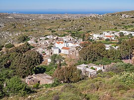
 The village, situated below the crest of a ridge, photographer looking north to the sea of Crete from a high point of the Zakros mountains. | |
| Coordinates: 35°07′53″N 26°10′14″E / 35.1313°N 26.1705°E | |
| Country | Greece |
| Administrative region | Crete |
| Regional unit | Lasithi |
| Municipality | Siteia |
| Municipal unit | Itanos |
| Elevation | 566 m (1,857 ft) |
| Population (2021)[1] | |
| • Community | 40 |
| Time zone | UTC+2 (EET) |
| • Summer (DST) | UTC+3 (EEST) |
| Postal code | 723 00 |
Karydi (Greek: Καρύδι), officially Καρύδιον (Σητείας), is a village in the highlands of east Crete, Greece, part of the municipal unit Itanos.[2] Under the Kallikratis Programme of 2011 it was made a local community (topiki koinoteta). Its chain of civic jurisdiction is as follows: municipal unit (demotike enoteta) Itanos, municipality (demos) Sitia, regional unit (periphereiakes enotetas) Lasithi, region (periphereia) Crete.[3]
The population record, and to some extent the population, varies to such a degree that it is not possible to find credible documentation of it. The Greek-speaking population is on the move from the country to the city, from the hill villages, which in many cases are closing down, to the ports and the plains. Athens, once a ruined and nearly abandoned city, now is home to half the population of Greece.
The cities offer a full run of services available to any large city in Europe. In the case of Itanos the movement is from the settlements to Palaikastro and Siteia.[4][i] The latter, housing several thousand, has the airport and seaport, the hospital and the educational institutions. The villages are by no means isolated. They are connected to Siteia by good roads, automobiles, and a bus service. In addition to making wine and oil, herding sheep and growing fruits and vegetables, they cater to the tourist business, resulting in an increase of summer populations in villages otherwise abandoned or nearly so.[5] Some industry also has found a place in the rural countryside, dotting it with scattered factories.[6] The improvement of the power grid has made this last trend possible.
Karydi is a community with a long tradition. It first appears in the deeds and maps of the 16th century, although not in the Venetian census of 1583.[2] The name appears to be based on the Greek word for walnut. There are, however, no walnut trees in the area.[7][ii] By chance a plaque of the times embossed with a walnut tree was found at Koutsounara, which might be hypothesized to be a heraldic symbol.[8] Perhaps a family displaying that symbol founded Karydi. Koutsounara, however, is on the south coast. Any supposition of a heraldic symbol or an unknown family or any connection to Karydi is entirely guesswork.
- ^ "Αποτελέσματα Απογραφής Πληθυσμού - Κατοικιών 2021, Μόνιμος Πληθυσμός κατά οικισμό" [Results of the 2021 Population - Housing Census, Permanent population by settlement] (in Greek). Hellenic Statistical Authority. 29 March 2024.
- ^ a b "Karidi". Crete Today. Retrieved 14 April 2020.
- ^ Cite error: The named reference
bukwas invoked but never defined (see the help page). - ^ Cunningham, Tim. "1". TFC thesis chap. 1; Palaikastro Crete (MA). Academia. p. 5. Retrieved 22 June 2022.
- ^ Fassoulas 2013, p. 22
- ^ Fassoulas 2013, p. 27
- ^ Mackridge, Peter (2020). "31. Toplou". The Crete of R.M. Dawkins (1903-1919). Oxford: University of Oxford. p. 350.
- ^ Biopolitics International Organization (2013). "Karidi" (PDF). Lasithi-Biotourism Map. Monuments of Nature and Culture. Ministry of Nature and Culture. ISBN 978-960-7508-59-1.
Cite error: There are <ref group=lower-roman> tags or {{efn-lr}} templates on this page, but the references will not show without a {{reflist|group=lower-roman}} template or {{notelist-lr}} template (see the help page).

