Kasba upazila
কসবা | |
|---|---|
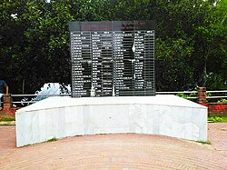
 Martyrs Memorial at Kullapathar | |
 | |
| Coordinates: 23°44′N 91°10′E / 23.733°N 91.167°E | |
| Country | |
| Division | Chittagong |
| District | Brahmanbaria |
| Area | |
| • Total | 209.77 km2 (80.99 sq mi) |
| • Urban | 16.86 km2 (6.51 sq mi) |
| Population | |
| • Total | 357,961 |
| • Density | 1,700/km2 (4,400/sq mi) |
| • Urban | 40,416 |
| Time zone | UTC+6 (BST) |
| Postal code | 3460[3] |
| Area code | 08524[4] |
| Website | kasba |
Kasba (Bengali: কসবা) is an upazila of Brahmanbaria District, Chittagong Division in east-central Bangladesh. It is located approximately 150 km north of Chittagong[5] and was part of greater Comilla District until 1984.[6]
- ^ Cite error: The named reference
census2011was invoked but never defined (see the help page). - ^ National Report (PDF). Population and Housing Census 2022. Vol. 1. Dhaka: Bangladesh Bureau of Statistics. November 2023. p. 396. ISBN 978-9844752016.
- ^ "Bangladesh Postal Code". Dhaka: Bangladesh Postal Department under the Department of Posts and Telecommunications of the Ministry of Posts, Telecommunications and Information Technology of the People's Republic of Bangladesh. 20 October 2024.
- ^ "Bangladesh Area Code". China: Chahaoba.com. 18 October 2024.
- ^ Kumar, Gautam Bera (2010). The Land of Fourteen Gods: Ethno-cultural Profile of Tripura. Mittal Publications. pp. 46–. ISBN 978-81-8324-333-9. Retrieved October 7, 2012.
- ^ Musa, Muhammad. Brahmanbariar Itibrittyo, Shetu Prokashoni, Brahmanbaria, 1998.