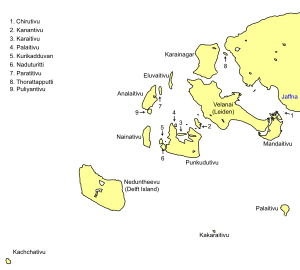
Native name: கச்சத்தீவு | |
|---|---|
| Geography | |
| Coordinates | 9°23′0″N 79°31′0″E / 9.38333°N 79.51667°E |
| Area | 285 acres (115 ha)[1][2] |
| Length | 1.6 km (0.99 mi)[1] |
| Width | 300 m (1000 ft)[1] |
| Administration | |
| Province | Northern |
| District | Jaffna |
| DS Division | Delft |
| Additional information | |
| Time zone | |

Katchatheevu (Tamil: கச்சத்தீவு, Tamil pronunciation: [kəttʃət̪t̪iːʋʉ])[a] is an uninhabited island in Sri Lanka. The island was governed by British Ceylon (now Sri Lanka) from 1921.[3] Though the Indian government never controlled it, the island remained disputed until 1974 between India and Sri Lanka when India recognised Sri Lanka's sovereignty over the island.[4][5]
The island is located between Neduntheevu, Sri Lanka and Rameswaram, India and has been traditionally used by both Sri Lankan Tamil and Tamil Nadu fishermen.[6][7] In 1974, then Prime Minister of India, Indira Gandhi accepted Katchatheevu as Sri Lankan territory under the Indo-Sri Lankan Maritime agreement aimed at resolving the maritime boundaries in the Palk Strait.[7] Another agreement signed in 1976 restricted both the countries' fishermen from fishing in the other's exclusive economic zones.[7]
Earlier, it had been owned by the Ramnad Kingdom of Ramanathapuram Rameshwaram which later came under the Madras Presidency during British rule of the Indian subcontinent. By 1920, Ceylon had reinstated its claims to Katchatheevu and the island found itself within Ceylonese territory in 1921.[3][7]
- ^ a b c Sengupta, Arjun (31 March 2024). "Did Congress 'give away' Katchatheevu island to Sri Lanka?". The Indian Express. Retrieved 31 March 2024.
- ^ Tamil Nadu (India); Nagarajan, N.; Subramanian, K. (1977). History of Land Revenue Settlement and Abolition of Intermediary Tenures in Tamil Nadu. Government of Tamil Nadu. p. 195.
- ^ a b Chatterjee, A.K. (2024). Adam's Bridge: Sacrality, Performance, and Heritage of an Oceanic Marvel. Ocean and Island Studies. Taylor & Francis. p. 165. ISBN 978-1-003-85912-3. Retrieved 2024-03-31.
- ^ Cite error: The named reference
:asianwas invoked but never defined (see the help page). - ^ Tamil Nadu (India); Nagarajan, N.; Subramanian, K. (1977). History of Land Revenue Settlement and Abolition of Intermediary Tenures in Tamil Nadu. Government of Tamil Nadu. p. 196.
This was followed up by a meeting of the officials of India and Sri Lanka at Delhi when they decided to adopt the median line as the line of demarcation with a deviation around Katchatheevu including it in Sri Lanka's limits
- ^ Malone, David M.; Mohan, C. Raja; Raghavan, Srinath (2015-07-23). The Oxford Handbook of Indian Foreign Policy. OUP Oxford. ISBN 9780191061196.
- ^ a b c d Katchatheevu: The big issue over a small island, Livemint, 15 Jun 2016.
Cite error: There are <ref group=lower-alpha> tags or {{efn}} templates on this page, but the references will not show without a {{reflist|group=lower-alpha}} template or {{notelist}} template (see the help page).
