This article needs additional citations for verification. (October 2009) |
| UNESCO World Heritage Site | |
|---|---|
 Kathmandu valley seen from the space by the NASA Earth Observatory | |
| Location | Bagmati Province, Nepal |
| Criteria | Cultural: (iii), (iv), (vi) |
| Reference | 121bis |
| Inscription | 1979 (3rd Session) |
| Extensions | 2006 |
| Endangered | 2003–2007[1] |
| Area | 665 km2 (257 sq mi) |
| Coordinates | 27°42′14″N 85°18′31″E / 27.70389°N 85.30861°E |

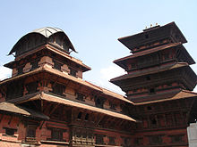
The Kathmandu Valley (Nepali: काठमाडौं उपत्यका), also known as the Nepal Valley or Nepa Valley (Nepali: नेपाः उपत्यका, Nepal Bhasa: 𑐣𑐾𑐥𑐵𑑅 𑐐𑐵𑑅, नेपाः गाः), National Capital Area, is a bowl-shaped valley located in the Himalayan mountains of Nepal. It lies at the crossroads of ancient civilizations of the Indian subcontinent and the broader Asian continent, and has at least 130 important monuments, including several pilgrimage sites for Hindus and Buddhists. The valley holds seven World Heritage Sites within it.[2]
The Kathmandu Valley is the most developed and the largest urban agglomeration in Nepal with a population of about 5 million people.[3] The urban agglomeration of Kathmandu Valley includes the cities of Kathmandu, Lalitpur, Bhaktapur, Changunarayan, Budhanilkantha, Tarakeshwar, Gokarneshwar, Suryabinayak, Tokha, Kirtipur, Madhyapur Thimi, and others. The majority of offices and headquarters are located in the valley, making it the economic hub of Nepal. It is popular with tourists for its unique architecture, and rich culture which includes the highest number of jatras (festivals) in Nepal. Kathmandu Valley itself was referred to as "Nepal Proper" by British historians. As per the World Bank, the Kathmandu Valley was one of the fastest growing metropolitan areas in South Asia with 2.5 million population by 2010 and an annual growth rate of 4%.[4]
In 2015, Kathmandu Valley was hit by the April 2015 Nepal earthquake.[5] The earthquake caused thousands of deaths and the destruction of many infrastructure across the Kathmandu Valley, which included the towns of Lalitpur, Kirtipur, Madhyapur Thimi, Changunarayan, and Bhaktapur. Kathmandu is also the largest city in the Himalayan hill region.
- ^ Royal Palaces of Abomey and Kathmandu removed from Danger List Archived 6 August 2022 at the Wayback Machine at UNESCO website
- ^ Centre, UNESCO World Heritage. "Kathmandu Valley". whc.unesco.org. Archived from the original on 31 October 2005. Retrieved 8 September 2018.
- ^ "Archived copy" (PDF). cbs.gov.np. Archived from the original (PDF) on 6 February 2022. Retrieved 22 February 2022.
{{cite web}}: CS1 maint: archived copy as title (link) - ^ "Managing Nepal's Urban Transition". World Bank. Archived from the original on 2 November 2019. Retrieved 1 December 2019.
- ^ "Nepal Disaster Risk Reduction Portal". Government of Nepal. Archived from the original on 24 October 2021. Retrieved 5 May 2015.


