This article needs additional citations for verification. (October 2022) |
Katsuragi
葛󠄀城市 | |
|---|---|
 | |
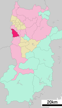
 Location of Katsuragi in Nara Prefecture | |
| Coordinates: 34°29′N 135°44′E / 34.483°N 135.733°E | |
| Country | Japan |
| Region | Kansai |
| Prefecture | Nara Prefecture |
| Government | |
| • Mayor | Kazuhiko Ako |
| Area | |
• Total | 33.73 km2 (13.02 sq mi) |
| Population (August 1, 2019) | |
• Total | 37,352 |
| • Density | 1,107/km2 (2,870/sq mi) |
| Time zone | UTC+09:00 (JST) |
| City hall address | 166 Kakinomoto, Katsuragi-shi, Nara-ken 639-2195 |
| Website | www |
| Symbols | |
| Bird | Japanese bush warbler |
| Flower | Peony and chrysanthemum |
| Tree | Quercus gilva and camphor laurel |
Katsuragi (葛󠄀城市, Katsuragi-shi) is a city located in Nara Prefecture, Japan. As of August 1, 2019, the city has an estimated population of 37,352, and 14,775 households.[1] The population density is 1,107 persons per km2, and the total area is 33.73 km2.[citation needed]
The modern city of Katsuragi was established on October 1, 2004, from the merger of the towns of Shinjō and Taima (both from Kitakatsuragi District).
Katsuragi has a deep history being located in the ancient capital of Japan, Nara. Katsuragi has many temples, shrines and tombs, many which contain important national treasures and important cultural properties.
Katsuragi has a rich natural environment. To the west lies the Kongo ranges which includes the mountains of Mt. Nijo, Mt. Iwahashi and Mt. Katsuragi.
The east side of Katsuragi City includes the commercial and residential areas with National Route 24, railway stations and the Katsuragi River.
The climate is generally mild and is classified as an inland climate. The temperature change during the day can be wide. It is hot in summer and cold in winter with a little bit of snow.
- ^ "Official website of Katsuragi city" (in Japanese). Japan: Katsuragi City. Retrieved August 30, 2019.


