Kaumakani, Hawaii | |
|---|---|
 2004 aerial view of Pakala Village | |
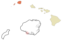
 Location in Kauai County and the state of Hawaii | |
| Coordinates: 21°55′13″N 159°37′27″W / 21.92028°N 159.62417°W | |
| Country | United States |
| State | Hawaii |
| County | Kauai |
| Area | |
• Total | 1.06 sq mi (2.74 km2) |
| • Land | 0.95 sq mi (2.46 km2) |
| • Water | 0.11 sq mi (0.29 km2) |
| Elevation | 151 ft (46 m) |
| Population (2020) | |
• Total | 672 |
| • Density | 708.11/sq mi (273.47/km2) |
| Time zone | UTC-10 (Hawaii-Aleutian) |
| ZIP code | 96747 96769 |
| Area code | 808 |
| FIPS code | 15-30650 |
| GNIS feature ID | 0360693 |
Kaumakani (literally, "place in the wind" in the Hawaiian language[2]) is a census-designated place (CDP) in Kauaʻi County, Hawaiʻi, United States. The population was 749 at the 2010 census,[3] up from 607 at the 2000 census.
- ^ "2020 U.S. Gazetteer Files". United States Census Bureau. Retrieved December 18, 2021.
- ^ Lloyd J. Soehren (2010). "lookup of Kaumakani ". in Hawaiian Place Names. Ulukau, the Hawaiian Electronic Library. Retrieved October 12, 2010.
- ^ "Geographic Identifiers: 2010 Demographic Profile Data (G001): Kaumakani CDP, Hawaii". American Factfinder. U.S. Census Bureau. Retrieved January 31, 2019.[dead link]