This article needs additional citations for verification. (October 2023) |
 Kavaratti Island | |
| Geography | |
|---|---|
| Location | Arabian Sea |
| Coordinates | 10°34′N 72°38′E / 10.57°N 72.64°E |
| Archipelago | Lakshadweep |
| Adjacent to | Indian Ocean |
| Total islands | 1 |
| Major islands |
|
| Area | 3.93 km2 (1.52 sq mi)[1] |
| Length | 5 km (3.1 mi) |
| Width | 1.5 km (0.93 mi) |
| Highest elevation | 1 m (3 ft) |
| Administration | |
| Territory | |
| District | Lakshadweep |
| Island group | Laccadive Islands |
| Tehsils of India | Kavaratti |
| Subdivisions of India | Kavaratti |
| Largest settlement | Kavaratti (pop. 10,000) |
| Demographics | |
| Population | 11,473 (2014) |
| Pop. density | 2,920/km2 (7560/sq mi) |
| Ethnic groups | Malayali, Mahls |
| Additional information | |
| Time zone | |
| PIN | 682555 |
| Telephone code | 04896 |
| ISO code | IN-LD-05[2] |
| Official website | lakshadweep |
| Literacy | 88.6% |
| Avg. summer temperature | 35 °C (95 °F) |
| Avg. winter temperature | 25 °C (77 °F) |
| Sex ratio | 1.227 ♂/♀ |
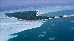
Kavaratti (/kʌvəˈrʌti/, Malayalam: [kɐʋɐɾɐt̪ːi]) is the capital of the Union Territory of Lakshadweep in India. Kavaratti is a census town as well as the name of the atoll upon which the town stands. It is well known for its pristine white sand beaches and calm lagoons, which makes it a popular tourist destination. It is located 332 km (206 mi) west to the city of Kannur, 351 km (218 mi) west of the city of Kozhikode, and 404 km (251 mi) west of the city of Kochi.
- ^ "Islandwise Area and Population - 2011 Census" (PDF). Government of Lakshadweep. Archived from the original (PDF) on 22 July 2016.
- ^ Registration Plate Numbers added to ISO Code

