Kawerau | |
|---|---|
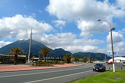
 Kawerau, with Putauaki in the background | |
 Kawerau district within the North Island | |
| Coordinates: 38°06′S 176°42′E / 38.100°S 176.700°E | |
| Country | New Zealand |
| Region | Bay of Plenty |
| Established | 1953 |
| Electorates | East Coast (general) Waiariki (Māori) |
| Government | |
| • Mayor | Faylene Tunui |
| • Territorial authority | Kawerau District Council |
| Area | |
| • Land | 23.56 km2 (9.10 sq mi) |
| Population (June 2024)[2] | |
• District | 7,610 |
| • Urban | 7,610 |
| Time zone | UTC+12 (NZST) |
| • Summer (DST) | UTC+13 (NZDT) |
| Postcode | 3127 |
| Area code | 07 |
| Website | Kawerau District Council |
Kawerau is a town in the Bay of Plenty Region on the North Island of New Zealand. It is situated 100 km south-east of Tauranga and 58 km east of Rotorua.[3] It is the seat of the Kawerau District Council, and the only town in Kawerau District.
Kawerau is a small community, with an economy that is largely driven by the nearby pulp and paper mill that is run by Norske Skog and OJI Fibre Solutions. It is located along State Highway 34, southwest of Onepu, and is the terminus of the East Coast Main Trunk Railway, and the commencing point of the Murupara Branch railway.
Kawerau is among the three towns in New Zealand with a majority Māori population, along with Ōpōtiki and Wairoa. Kawerau was one of the worst-affected towns in the 1987 Edgecumbe earthquake.
- ^ Cite error: The named reference
Areawas invoked but never defined (see the help page). - ^ "Aotearoa Data Explorer". Statistics New Zealand. Retrieved 26 October 2024.
- ^ Te Ara – the Encyclopedia of New Zealand: Kawerau