Kawthaung
ကော့သောင်းမြို့ Kawthoung | |
|---|---|
Town | |
| Kawthaung | |
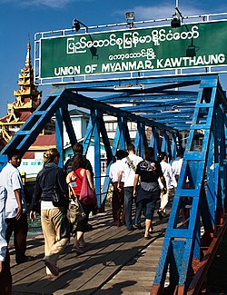
 Border crossing at Kawthaung | |
| Coordinates: 9°59′N 98°33′E / 9.983°N 98.550°E | |
| Country | |
| Region | |
| District | Kawthaung |
| Township | Kawthaung Township |
| Population (2021) | |
• Total | 57,949 |
| Demonym | Kawthaunggese |
| Time zone | UTC+6.30 (MMT) |
Kawthaung (Burmese: ကော့သောင်း; MLCTS: kau. saung:, pronounced [kɔ̰θáʊ̯ɰ̃]; Mon: ကအ်ပိ; Thai: เกาะสอง; RTGS: Ko Song, pronounced [kɔ̀ʔ sɔ̌ːŋ]; Malay: Pulodua, ڤولودوا) is a border town located in the southernmost part of Myanmar, in the Tanintharyi Region. During British rule in Burma between 1824 and 1948, it was known as Victoria Point. As of 2021, it has a population of 57,949.[1] Facing Ranong in Thailand, Kawthaung is one of 7 official border trade posts with Thailand.
- ^ "Population of Cities in Myanmar (2021)". worldpopulationreview.com. Retrieved 2021-04-01.
