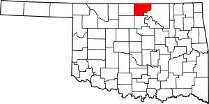
Kay County | |
|---|---|
 Kay County Courthouse in Newkirk (2010) | |
 Location within the U.S. state of Oklahoma | |
 Oklahoma's location within the U.S. | |
| Coordinates: 36°49′N 97°08′W / 36.81°N 97.14°W | |
| Country | |
| State | |
| Founded | 1893 |
| Seat | Newkirk |
| Largest city | Ponca City |
| Area | |
| • Total | 945 sq mi (2,450 km2) |
| • Land | 920 sq mi (2,400 km2) |
| • Water | 25 sq mi (60 km2) 2.7% |
| Population (2020) | |
| • Total | 43,700 |
| • Density | 46/sq mi (18/km2) |
| Time zone | UTC−6 (Central) |
| • Summer (DST) | UTC−5 (CDT) |
| Congressional district | 3rd |
| Website | www |
Kay County is a county located in the U.S. state of Oklahoma. As of the 2020 census, its population was 43,700.[1] Its county seat is Newkirk,[2] and the largest city is Ponca City.
Kay County comprises the Ponca City micropolitan statistical area. It is in north-central Oklahoma on the Kansas state line.
Before statehood, Kay County was formed from the "Cherokee Strip" or "Cherokee Outlet" and originally designated as county "K". Its name means simply that.[3][4] Kay County is the only county to keep its same name as the Oklahoma area moved from a territory to a state.
- ^ "Kay County, Oklahoma". United States Census Bureau. Retrieved May 13, 2023.
- ^ "Find a County". National Association of Counties. Archived from the original on May 31, 2011. Retrieved June 7, 2011.
- ^ Linda D. Wilson, "KayCounty." Encyclopedia of Oklahoma History and Culture.
- ^ Gannett, Henry (1905). The Origin of Certain Place Names in the United States. Govt. Print. Off. pp. 172.