Kearney, Nebraska | |
|---|---|
 The Great Platte River Road Archway Monument, which spans Interstate 80 | |
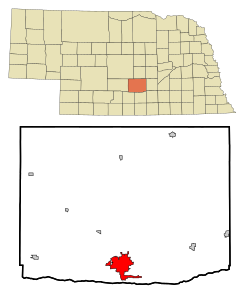
 Location of Kearney within Nebraska and Buffalo County | |
| Coordinates: 40°42′06″N 99°04′57″W / 40.70167°N 99.08250°W | |
| Country | United States |
| State | Nebraska |
| County | Buffalo |
| Government | |
| • Type | Council–manager[1] |
| • Mayor | Stan Clouse |
| Area | |
• Total | 15.15 sq mi (39.25 km2) |
| • Land | 14.88 sq mi (38.53 km2) |
| • Water | 0.28 sq mi (0.72 km2) |
| Elevation | 2,152 ft (656 m) |
| Population (2020) | |
• Total | 33,790 |
| • Density | 2,271.29/sq mi (876.95/km2) |
| Time zone | UTC−6 (Central (CST)) |
| • Summer (DST) | UTC−5 (CDT) |
| ZIP codes | 68845, 68847, 68848 (P.O. Box), 68849 UNK |
| Area code | 308 |
| FIPS code | 31-25055 |
| GNIS feature ID | 838076[3] |
| Website | www |
Kearney (/ˈkɑːrni/ KAR-nee)[4] is the county seat of Buffalo County, Nebraska, United States.[5] The population was 33,790 in the 2020 census, making it the 5th most populous city in Nebraska.[6] It is home to the University of Nebraska at Kearney. The westward push of the railroad as the Civil War ended gave new birth to the community.[7]
- ^ "Government". City of Kearney, NE - official website. City of Kearney. Retrieved December 16, 2019.
- ^ "ArcGIS REST Services Directory". United States Census Bureau. Retrieved September 18, 2022.
- ^ a b U.S. Geological Survey Geographic Names Information System: Kearney, Nebraska
- ^ "Nebraska Pronunciation Guide". Associated Press. Archived from the original on March 12, 2010. Retrieved January 28, 2010.
- ^ "Find a County". National Association of Counties. Archived from the original on May 31, 2011. Retrieved June 7, 2011.
- ^ Giboney, Sara (March 14, 2011). "Indeed, yes: UNK students counted as Kearneyites in the census". kearneyhub.com. Local news.
- ^ "About Kearney". Kearney, Nebraska: Kearney Visitors Bureau.