| Kelley Point Park | |
|---|---|
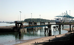
 View up the Columbia River from the park, 2008 | |
 | |
| Type | Urban park |
| Location | N Marine Dr. and Lombard St. Portland, Oregon |
| Coordinates | 45°38′59″N 122°45′49″W / 45.649838°N 122.763711°W |
| Area | 104.69 acres (42.37 ha) |
| Created | 1984 |
| Operated by | Portland Parks & Recreation |
| Status | Open 6 a.m. to 9 p.m. daily |
Kelley Point Park is a city park in north Portland in the U.S. state of Oregon. Bounded by the Columbia Slough on the south, the Willamette River on the west, and the Columbia River on the north, the park forms the tip of the peninsula at the confluence of the rivers.[1] Marine Terminal 6 of the Port of Portland lies immediately east of the park along the Columbia, while Terminal 5 is along the Willamette slightly south of the Columbia Slough.[2] The park is at 45°38′59″N 122°45′49″W / 45.6498384°N 122.7637106°W and rises to an elevation of 39 feet (12 m) above sea level.[3] Sauvie Island is west of the park across the Willamette River.[4] Hayden Island is slightly upstream of the park on the Columbia River opposite Marine Terminal 6.[4]
- ^ Cite error: The named reference
Parkswas invoked but never defined (see the help page). - ^ "Facilities Map". Port of Portland. 2005. Archived from the original on December 20, 2008. Retrieved December 27, 2008.
- ^ "Kelley Point City Park". Geographic Names Information System. United States Geological Survey. May 1, 1994. Retrieved December 28, 2008.
- ^ a b Cite error: The named reference
topoquestwas invoked but never defined (see the help page).