| Kelling | |
|---|---|
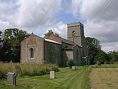
 St Marys Kelling Parish Church. | |
Location within Norfolk | |
| Area | 8.06 km2 (3.11 sq mi) |
| Population | 177 (parish, 2011 census)[1] |
| • Density | 22/km2 (57/sq mi) |
| OS grid reference | TG094429 |
| • London | 130 miles (210 km) |
| Civil parish |
|
| District | |
| Shire county | |
| Region | |
| Country | England |
| Sovereign state | United Kingdom |
| Post town | HOLT |
| Postcode district | NR25 |
| Dialling code | 01263 |
| Police | Norfolk |
| Fire | Norfolk |
| Ambulance | East of England |
| UK Parliament | |
Kelling (also known as Low Kelling and as Lower Kelling)[2] is a village and a civil parish in the English county of Norfolk. The village is 10.1 miles (16.3 km) west of Cromer, 26 miles (42 km) north of Norwich, and 130 miles (210 km) northeast of London. The village straddles the A149 Coast road between Kings Lynn and Great Yarmouth.
The villages name means 'Cylla's/Ceolla's people'.[3]
The nearest railway station is at Sheringham for the Bittern Line which runs between Sheringham, Cromer, and Norwich. The nearest airport is Norwich International Airport. The village lies within the Norfolk Coast AONB (Area of Outstanding Natural Beauty) and the North Norfolk Heritage Coast.
Changes in government policy have discontinued management of coastal erosion in North Norfolk.[4]
- ^ "Civil Parish population 2011". Retrieved 1 September 2015.
- ^ GENUKI: Norfolk: Genealogy: Towns and Parishes: Kelling
- ^ place name meaning
- ^ [1] Archived October 30, 2007, at the Wayback Machine
