| Kendenup Western Australia | |||||||||||||||
|---|---|---|---|---|---|---|---|---|---|---|---|---|---|---|---|
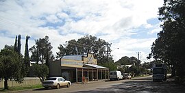
 Ridge Brothers general store, Hassell Avenue, Kendenup | |||||||||||||||
 | |||||||||||||||
| Coordinates | 34.486°0′S 117.629°0′E / 34.486°S 117.629°E | ||||||||||||||
| Population | 422 (UCL 2021)[1] | ||||||||||||||
| Established | 1840 | ||||||||||||||
| Postcode(s) | 6323 | ||||||||||||||
| Area | 388.3 km2 (149.9 sq mi) | ||||||||||||||
| Location |
| ||||||||||||||
| LGA(s) | Shire of Plantagenet | ||||||||||||||
| State electorate(s) | Warren-Blackwood | ||||||||||||||
| Federal division(s) | O'Connor | ||||||||||||||
| |||||||||||||||
Kendenup is a small town and locality in the Great Southern region of Western Australia, within the Shire of Plantagenet.[2][3] It is known for its view of Porongurup Range and the Stirling Range. It is 345 kilometres (214 mi) south east of Perth and 22 kilometres (14 mi) north of Mount Barker. The Great Southern Railway (established 1889) passes through the town, being one of the original stations on the line. At the 2006 census, Kendenup had a population of 1,290.[4]
The town was once the centre of a vast sheep station, and was, in the early years of the Western Australian colony, one of the largest farming enterprises so far established.
At the time of the first European discovery, the area was known to local Aboriginals as "Moor-ilup".[5] "Kendenup" is another local indigenous word which was used to describe the area.[6]
The upper reach of the Kalgan River runs nearby.
- ^ Australian Bureau of Statistics (28 June 2022). "Kendenup (urban centre and locality)". Australian Census 2021.
- ^ "SLIP Map". maps.slip.wa.gov.au. Landgate. Retrieved 15 October 2024.
- ^ "NationalMap". nationalmap.gov.au. Geoscience Australia. Retrieved 15 October 2024.
- ^ Australian Bureau of Statistics (25 October 2007). "Kendenup (State Suburb)". 2006 Census QuickStats. Retrieved 16 July 2011.
- ^ Cite error: The named reference
hcwawas invoked but never defined (see the help page). - ^ "History of country town names – K". Western Australian Land Information Authority. Archived from the original on 14 March 2022. Retrieved 21 July 2008.
