| Kent Falls State Park | |||||||||||||||||
|---|---|---|---|---|---|---|---|---|---|---|---|---|---|---|---|---|---|
 Kent Falls | |||||||||||||||||
| Location | Kent, Connecticut, United States | ||||||||||||||||
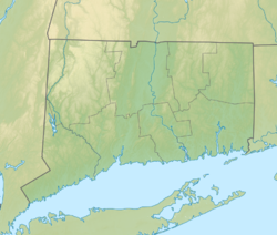
| Coordinates | 41°46′37″N 73°25′09″W / 41.77694°N 73.41917°W[1] | ||||||||||||||||
| Area | 307 acres (124 ha)[2] | ||||||||||||||||
| Elevation | 794 ft (242 m)[1] | ||||||||||||||||
| Established | 1919 | ||||||||||||||||
| Administered by | Connecticut Department of Energy and Environmental Protection | ||||||||||||||||
| Designation | Connecticut state park | ||||||||||||||||
| Website | Official website | ||||||||||||||||
| |||||||||||||||||
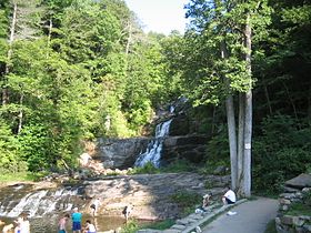
Kent Falls State Park is a public recreation area located in the town of Kent, Connecticut, within the Litchfield Hills region of the southern Berkshires. The state park is home to Kent Falls, a series of waterfalls on Falls Brook, a tributary of the Housatonic River.[3] The falls drop 250 feet (76 m) in under a quarter mile. The largest cascade drops more than 70 feet (21 m) into a reflecting pool, before traveling over the lesser falls.[4]
- ^ a b "Kent Falls Brook". Geographic Names Information System. United States Geological Survey, United States Department of the Interior.
- ^ Cite error: The named reference
pristaffwas invoked but never defined (see the help page). - ^ Cite error: The named reference
DEEPwas invoked but never defined (see the help page). - ^ Cite error: The named reference
waterfallwas invoked but never defined (see the help page).


