Kentucky Camp Historic District | |
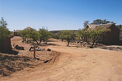
 Kentucky Camp in 2014. | |
| Location | Santa Rita Mountains, Arizona, USA |
|---|---|
| Nearest city | Sonoita, Arizona |
| Coordinates | 31°44′40″N 110°44′31″W / 31.74444°N 110.74194°W |
| Area | 340 acres (140 ha) |
| Built | 1905 |
| Architect | George B. McAneny; James B. Stetson |
| NRHP reference No. | 95001312[1] |
| Added to NRHP | November 22, 1995 |
Kentucky Camp is a ghost town and former mining camp along the Arizona Trail in Pima County, Arizona, United States, near the community of Sonoita. The Kentucky Camp Historic District is listed on the National Register of Historic Places and has been since 1995.[1] As it is located within Coronado National Forest, the United States Forest Service is responsible for the upkeep of the remaining buildings within the Kentucky Camp Historic District.[2]
- ^ a b "National Register Information System". National Register of Historic Places. National Park Service. July 9, 2010.
- ^ Nintzel, Jim (July 6, 2006). "Ghost Town". Tucson Weekly. Retrieved August 13, 2018.

