 Kentucky Route 10 | ||||
|---|---|---|---|---|
 | ||||
| Route information | ||||
| Maintained by KYTC | ||||
| Length | 117.760 mi[1] (189.516 km) | |||
| Component highways | ||||
| Major junctions | ||||
| West end | ||||
| ||||
| East end | ||||
| Location | ||||
| Country | United States | |||
| State | Kentucky | |||
| Counties | Campbell, Pendleton, Bracken, Mason, Lewis, Greenup | |||
| Highway system | ||||
| ||||
| ||||
Kentucky Route 10 (KY 10) is a highway maintained by the Kentucky Transportation Cabinet (KYTC) that runs from Alexandria (a suburb of Cincinnati, Ohio) to the Jesse Stuart Memorial Bridge at Lloyd, roughly north of Greenup, Kentucky, where the route continues into Ohio as State Route 253 (SR 253).
Part of its route, from Ribolt to east of Vanceburg in Lewis County, is along KY 9. This section of KY 10, along with the section from Vanceburg to US Route 23 (US 23) just before the Jesse Stuart Memorial Bridge, is signed as part of the AA Highway.
According to Geotab, a telematics company, KY 10 is among the least traveled highways in the state of Kentucky.[2]
-

-
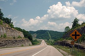 AA Hwy/KY 10 in Greenup County, Kentucky
 -
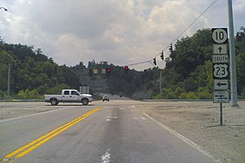 A view of the intersection of US 23, KY 10, and SR 253 just after crossing the Jesse Stuart Memorial Bridge in Greenup


- ^ Division of Planning. "Official Milepoint Route Log Extract". Highway Information System. Kentucky Transportation Cabinet. Retrieved July 7, 2013.
- ^ "America's Quietest Routes". Geotab.