| Kern River Río de San Felipe, La Porciúncula, Po-sun-co-la, Porsiuncula River[1] | |
|---|---|
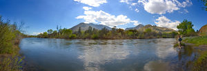
 Panorama of the upper Kern River | |
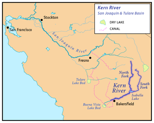
 Map of the San Joaquin and Tulare Basin region with the Kern River highlighted. Some rivers shown are intermittent or normally dry. A few selected canals are shown. Below: Map of the San Joaquin and Tulare Basin region showing the old lakes and river courses. | |
| Location | |
| Country | United States |
| State | California |
| Region | Sierra Nevada, San Joaquin Valley |
| District | Tulare County, Kern County |
| City | Bakersfield |
| Physical characteristics | |
| Source | Kings-Kern Divide |
| • location | Sequoia National Park |
| • coordinates | 36°41′48″N 118°23′53″W / 36.69667°N 118.39806°W[2] |
| • elevation | 13,608 ft (4,148 m)[3] |
| Mouth | Buena Vista Lake Bed |
• location | San Joaquin Valley |
• coordinates | 35°16′4″N 119°18′25″W / 35.26778°N 119.30694°W[2] |
• elevation | 299 ft (91 m)[2] |
| Length | 164 mi (264 km)[2] |
| Basin size | 3,612 sq mi (9,360 km2)[4] |
| Discharge | |
| • location | Near Democrat Springs, CA[5] |
| • average | 946 cu ft/s (26.8 m3/s)[5] |
| • minimum | 10 cu ft/s (0.28 m3/s) |
| • maximum | 47,000 cu ft/s (1,300 m3/s) |
| Type | Wild, Scenic, Recreational |
| Designated | November 24, 1987 |
The Kern River is an Endangered, Wild and Scenic river in the U.S. state of California, approximately 165 miles (270 km) long. It drains an area of the southern Sierra Nevada mountains northeast of Bakersfield. Fed by snowmelt near Mount Whitney, the river passes through scenic canyons in the mountains and is a popular destination for whitewater rafting and kayaking. It is the southernmost major river system in the Sierra Nevada, and is the only major river in the Sierra that drains in a southerly direction.
The Kern River formerly emptied into the now dry Buena Vista Lake and Kern Lake via the Kern River Slough, and Kern Lake in turn emptied into Buena Vista Lake via the Connecting Slough at the southern end of the Central Valley. Buena Vista Lake, when overflowing, first backed up into Kern Lake and then upon rising higher drained into Tulare Lake via Buena Vista Slough and a changing series of sloughs of the Kern River. The lakes were part of a partially endorheic basin that sometimes overflowed into the San Joaquin River.[6] This basin also included the Kaweah and Tule Rivers, as well as southern distributaries of the Kings River that all flowed into Tulare Lake.
Since the late 19th century the Kern has been almost entirely diverted for irrigation, recharging aquifers, and the California Aqueduct, although some water empties into Lake Webb and Lake Evans, two small lakes in a portion of the former Buena Vista lakebed. The lakes were created in 1973 for recreational use. The lakes hold 6,800 acre⋅ft (8,400 dam3) combined.[7] Crops are grown in the rest of the former lakebed. In extremely wet years the river will reach the Tulare Lake basin through a series of sloughs and flood channels.
Despite its remote source, nearly all of the river is publicly accessible. The Kern River is particularly popular for wilderness hiking and whitewater rafting. The Upper Kern River is paralleled by trails to within a half-mile of its source (which lies at 13,600 feet (4,100 m)). Even with the presence of Lake Isabella, the river is perennial down to the lower Tulare Basin. Its swift flow at low elevation makes the river below the reservoir a popular location for rafting.
- ^ Cite error: The named reference
Guddewas invoked but never defined (see the help page). - ^ a b c d U.S. Geological Survey Geographic Names Information System: Kern River, GNIS
- ^ Google Earth elevation for GNIS coordinates.
- ^ "Boundary Descriptions and Names of Regions, Subregions, Accounting Units and Cataloging Units". U.S. Geological Survey. Retrieved August 22, 2010.
- ^ a b Water Resources Data California, Water Year 2004, Volume 3, USGS
- ^ ECORP Consulting, Inc. (2007), Tulare Lake basin hydrology and hydrography: a summary of the movement of water and aquatic species (PDF), U.S. Environmental Protection Agency, retrieved May 4, 2011
- ^ Buena Vista Aquatic Recreational Area