Kerr County | |
|---|---|
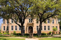
 Kerr County Courthouse, southside view | |
 Location within the U.S. state of Texas | |
 Texas's location within the U.S. | |
| Coordinates: 30°04′N 99°21′W / 30.06°N 99.35°W | |
| Country | |
| State | |
| Founded | 1856 |
| Named for | James Kerr |
| Seat | Kerrville |
| Largest city | Kerrville |
| Area | |
• Total | 1,107 sq mi (2,870 km2) |
| • Land | 1,103 sq mi (2,860 km2) |
| • Water | 4.0 sq mi (10 km2) 0.4% |
| Population (2020) | |
• Total | 52,598 |
| • Density | 48/sq mi (18/km2) |
| Time zone | UTC−6 (Central) |
| • Summer (DST) | UTC−5 (CDT) |
| Congressional district | 21st |
| Website | www |
Kerr County is a county located on the Edwards Plateau in the U.S. state of Texas. As of the 2020 census, its population was 52,598.[1] Its county seat is Kerrville.[2] The county was named by Joshua D. Brown for his fellow Kentucky native, James Kerr, a congressman of the Republic of Texas. The Kerrville, TX Micropolitan Statistical Area includes all of Kerr County.
- ^ "Kerr County, Texas". United States Census Bureau. Retrieved January 30, 2022.
- ^ "Find a County". National Association of Counties. Archived from the original on May 31, 2011. Retrieved June 7, 2011.